
GIS and Augmented Reality for learning
Author: Rakhmat Jaya Lahay, Indrawan, Mohamad Fachri Bokingo, Merlin Lauhi, Puspita Rahmat
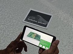
The combination of geospatial technology and augmented reality can be a tool in learning volcano morphology. These devices can facilitate user interaction with hard-to-reach objects such as volcanic objects. GIS is a technology for processing data that has spatial attributes, such as volcanic objects. The 3-dimensional shape of volcanic objects can be easily made with geospatial technology. Meanwhile, augmented reality technology can help users interact with virtual objects in the real world. Through the integration of these two technologies on mobile devices, volcanic geographic objects can be projected virtually in the real world.
Read more at https://jurnal.unimed.ac.id/2012/index.php/geo/article/view/43460
See the simulation at https://youtu.be/i6iArXh9GKU
(RJL)