
GIS and Augmented Reality for learning
Author: Rakhmat Jaya Lahay, Indrawan, Mohamad Fachri Bokingo, Merlin Lauhi, Puspita Rahmat
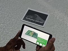
The combination of geospatial technology and augmented reality can be a tool in learning volcano morphology. These devices can facilitate user interaction with hard-to-reach objects such as volcanic objects. GIS is a technology for processing data that has spatial attributes, such as volcanic objects. The 3-dimensional shape of volcanic objects can be easily made with geospatial technology. Meanwhile, augmented reality technology can help users interact with virtual objects in the real world. Through the integration of these two technologies on mobile devices, volcanic geographic objects can be projected virtually in the real world.
Read more at https://jurnal.unimed.ac.id/2012/index.php/geo/article/view/43460
See the simulation at https://youtu.be/i6iArXh9GKU
(RJL)
EPUB Digital Module
Authors: Merlin Lauhi, Sri Maryati, Rakhmat Jaya Lahay
The advancement of information technology in the era of the 4th industrial revolution has prompted the educational sector to embrace digital media in the process of learning. The development of digital modules undoubtedly requires technological tools capable of effectively packaging content to support students' digital literacy. Consequently, the development tools for digital modules and the formatting of module publications have become crucial considerations. This research aims to develop digital modules in EPUB format using open-source software. The ADDIE model (Analysis, Design, Development, Implementation, Evaluation) is adapted for the development of these digital modules. Overall, the research results indicate that the study underwent validation processes by subject matter, media, and instructional experts, achieving a significantly high validation score. Furthermore, students' responses also displayed positivity with an average percentage falling within the "Very Good" category. The digital module can be effectively utilized as a learning medium within educational institutions to bolster students' digital literacy.
Lokasi Kampus Baru : Visualisasi Spasial dan Temporal 2002 s.d. 2019
Bismillah. Pembangunan kampus baru dimulai tahun 2017, dan diresmikan penggunaannya tahun 2019. Perubahan lahan karena adanya pembangunan di lokasi kampus baru dan sekitarnya terekam dengan baik oleh satelit sumber daya alam. Pemetaan spasial dan temporal di lokasi kampus baru dan sekitarnya dapat dilakukan dengan memanfaatkan teknologi geospasial dan metode yang sederhana. Video berikut dibuat memanfaatkan perangkat sederhan: laptop, aplikasi Google Earth Pro dan Video Editor. Visualisasi perubahan lahan baik spasial maupun temporal dapat dilihat pada video berikut:
Semoga bermanfaat dan selamat menempati kampus baru.
WebGIS dengan FOSS GIS
Bismillah, SIG berbasis web merupakan integrasi tekologi informasi geospasial ke dalam teknologi internet. Web sebagai salah satu layanan dalam teknologi internet, merupakan media yang baik untuk mempublikasikan data geospasial. Publikasi data geospasial melalui media internet menjadikan data tersebut mudah diakses oleh pengguna lain. Tulisan ini adalah tutorial singkat mengenai pemetaan web sig dengan menggunakan perangkat lunak geospasial yang gratis dan terbuka (Free and Open Source Software). Perangkat lunak QGIS menyediakan alat untuk memvisualisasikan peta ke web.
Beberapa pertanyaan dijawab melalui tutorial singkat ini adalah:
- Perangkat apa yang digunakan?
- Data apa saja yang perlukan?
- Bagaimana melakukan publikasi data geospasial secara online tanpa coding?
Baca tutorial klik disini. Semoga bermanfaat.
Visualisasi 3D menggunakan FOSSGIS dan DEMNAS
Bismillah. Visualisasi digital 3D data geospasial permukaan bumi dapat dilakukan dengan perangkat lunak SIG. Tersedia perangkat lunak SIG yang gratis dan terbuka, Free and Open Source Software GIS. Video berikut adalah keluaran dari pembuatan peta 3D dengan perangkat FOSSGIS dan DEMNAS:
Perangkat yang digunakan untuk membuat peta 3D seperti video pada link https://youtu.be/D_7yOTPWaSc , adalah:
- Komputer + OS MS Windows 10 (terima kasih Pustikom UNG untuk instalasi OSnya);
- QGIS 3.4.x dan plugin QGIS2threejs, dapat diunduh di qgis.org/en/site/;
- data DEMNAS diunduh dari http://tides.big.go.id/DEMNAS/
Demikian tulisan singkat, semoga bermanfaat.