Analisis Banjir Daerah Ilotidea Kabupaten Gorontalo Menggunakan Data Citra Radar SRTM

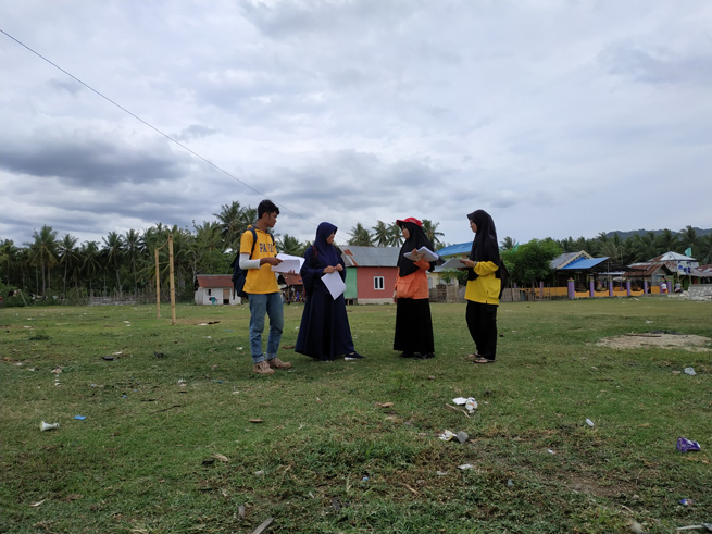
Ilotidea radar research team.
Floods are natural disasters that often occur in Indonesia, one of them in Gorontalo Province. Flood handling must begin with an understanding of flooding and geological conditions that have the potential to cause flooding. This study aims to determine the causes of flooding that occurred in the Ilotidea area based on the analysis of SRTM radar image data. SRTM data is processed and produces a 3D watershed hydrology surface model. Hydrological modeling is then carried out to obtain a 3D hydrological model on the surface of the Ilotidea region and its surroundings. Analysis of 3D watershed hydrology models and 3D hydrological models on the surface of the Ilotidea region and beyond to determine the causes of flooding in the Ilotidea region. Based on SRTM data, Ilotidea region consists of mountains morphology and lake plains. Surface modeling of 3D watershed hydrology shows that the Ilotidea region is in the Bolango watershed. The hydrological 3D surface model of the Ilotidea region shows that the flooding was caused by the overflow of Limboto Lake and Bolango River. Based on the results of the study, it can be concluded that when high-intensity rain occurs it will cause Limboto Lake and Bolango River to overflow, then causing flooding in the Ilotidea area.
Keywords: Flood, Radar, Hydrology, Gorontalo.
Tolodo, D. D., Suma, M. D., Yusuf, N. J., & Manyoe, I. N. (2019). Analisis Banjir Daerah Ilotidea Kabupaten Gorontalo Menggunakan Data Citra Radar SRTM. Jurnal Azimut, 2(1), 60-64.
Analisis Stratigrafi dan Rumusan Sejarah Geologi Daerah Limbato Dan Sekitarnya, Kabupaten Gorontalo Utara, Provinsi Gorontalo

Micrograph of Granodiorite (Rahman, 2019).
Regionally, the research area is composed of volcanic and plutonic rocks. Stratigraphic data of the study area are still regional scale. This study aims to analyze detailed stratigraphic data and formulate the geological history of the Limbato area and its surroundings. The area located at coordinates 0º56’6” - 1º0’10.8” N dan 122º5’56.4” - 122º9’10.8” E, the area of the study is around 45 km². The method used in the research is scientific exploration by conducting a surface geological mapping survey. The geological surface in the form of field data collection and laboratory analysis. Field data in the form of lithology data and laboratory analysis in the form of petrology and petrographic analysis. The stratigraphy of the research area is divided into 4 (four) unofficial units, which are sorted from old to young, namely granodiorite units of Middle Miocene age, volcanic breccia units of Late Miocene to Early Pliocene, andesite units of Middle Pliocene and alluvial units of Holocene age.Stratigraphic analysis of the Limbato area is related to geological history. In the Middle Miocene period subduction formed plutonic rocks that produced granodiorite units, then during the Late Miocene volcanic eruptions resulted in volcanic breccia units. The activity was stopped at the time of the Early Pliocene. After the volcanic activity was stopped, then new magma activity occurred at the time of the Middle Pliocene resulting in an andesite unit. After all rock units have been deposited, an erosion process occurs in older units which results in an alluvial unit.
Keywords: Geology, Granodiorite, Volcanic breccia, Andesite.
Rahman, M. R., Zainuri, A., & Manyoe, I. N. (2019). Analisis Stratigrafi dan Rumusan Sejarah Geologi Daerah Limbato Dan Sekitarnya, Kabupaten Gorontalo Utara, Provinsi Gorontalo. Jurnal Azimut, 2(1), 65-71.
Electrical and thermal efficiency of air-based photovoltaic thermal (PVT) systems: An overview

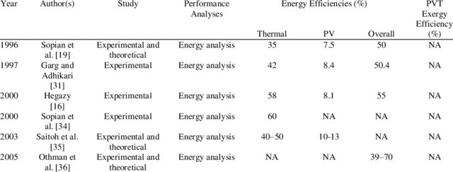
Performance of air-based PVT Systems.
The development of photovoltaic thermal (PVT) system is a very promising area of research. PVT systems using in various applications, such as solar drying, solar cooling, water heating, desalination, and pool heating. With the recognition of the potentials and contributions of PV system, considerable research has been conducted to attain the most advancement which may produce reliable and sustainable PVT system. The cooling system’s design refers to the absorber design which mostly focuses on water and air-based PVT systems. An air-based system has been developed through different absorber configurations, air flow modes and single- or double-pass design. Hence, a summarization on various research and development of air-based PVT system will be presented.
Keywords: Efficiency, Energy analysis, Exergy analysis, Photovoltaic, Solar energy.
Rukman, N. S. B., Fudholi, A., Taslim, I., Indrianti, M. A., Manyoe, I. N., Lestari, U., & Sopian, K. (2019). Electrical and thermal efficiency of air-based photovoltaic thermal (PVT) systems: An overview. Indonesian Journal of Electrical Engineering and Computer Science, 14(3), 1134-1140.
Energy and Exergy Efficiency of Water-Based Photovoltaic Thermal (PVT) Systems: An Overview

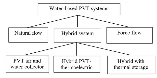
Classifications of flow pattern in water-based PVT systems.
Conventional fuels are not free, scarce and expensive, and its future cost and availability are uncertain. Hence, the usage of solar energy in applications will probably increase and further become economically feasible in the near future. Solar energy is free, clean, and renewable and has been widely used in electricity generation and thermal energy via photovoltaic thermal (PVT) system. PVT is a hybrid system consists of a PV panel and a solar collector in a single unit to simultaneously produce electricity and thermal energy. In this review, energy and exergy efficiency for water-based PVT systems is presented. As conclusion, the study on exergy is still limited and is recommended to be furthered in order to obtained useful energy generation by the system.
Rukman, N. S. B., Fudholi, A., Taslim, I., Indrianti, M. A., Manyoe, I. N., Lestari, U., & Sopian, K. (2019). Energy and Exergy Efficiency of Water-Based Photovoltaic Thermal (PVT) Systems: An Overview. Int J Pow Elec & Dri Syst, 10(2), 987-994.
Subsurface Structure Identification in Ilotidea Using Electrical Method for Developed the Flood Tourist Science Village

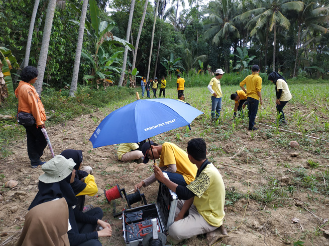
Electrical data collection.
Gorontalo is one area that is very vulnerable to flooding. Flood problems in Gorontalo must have a solution that can have a positive impact on the community and the government. The purpose of this research is to identification subsurface structure of the Ilotidea Region by using resistivity method. The result of this research will be used for the fundamental of developing the Flood Tourist Science Village. The method that used in this research is to take subsurface data by using the IPMGEO-4200 Electrical Resistivity Meter in 6 points at Ilotidea Village. Processing data through calculating the apparent resistivity (ρa) by entering the values ?V, I, R and K, then interpreting the subsurface structure of the Ilotidea region. Based on the results of the data analysis, there are obtained 5 layers at each data retrieval point. The layers found at each point are composed of sandy clay, clay, sand, clay, and sandstone. Based on the results of the interpretation of the subsurface structure, the sandy clay layer is arranged with a layer of clay which has the characteristic of not easily escaping the water. This causes the Ilotidea area to be very vulnerable to flooding because when surface runoff and rainfall falls into this area has a high intensity and volume it will cause inundation due to the absence of water absorbed by material found below the surface. Based on the subsurface structure of the Ilotidea region, the house foundation that will be made in a flood tourism science village must reach a depth of 5-10 m where at this depth the layer is a clay layer which is not easy to escape and elastic so the house is not easy to collapse.
Keywords: Lithology, Subsurface, Electrical, Flood Tourism, Ilotidea.
Tolodo, D. D., Suma, M. D., Yusuf, N. J., & Manyoe, I. N. (2019). Subsurface Structure Identification in Ilotidea Using Electrical Method for Developed the Flood Tourist Science Village. Jurnal Sains Informasi Geografi, 2(1), 44-49.
