
Kajian Mitigasi Bencana Tanah Longsor Ruas Jalan Meluhu-Lasolo, Sulawesi Tenggara
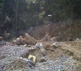
Limestone outcrop (Umar, 2019).
Geological hazards at Meluhu-Lasolo North Konawe are much more destructive when prevail can cause greater damage to lives and properties of humans when not properly and timely controlled and mitigated. This study aims to do an inventory of the types of disasters and determine all the locations that disaster-prone at Meluhu-Lasolo North Konawe Regency. The research method that will be used is an inductive method with approach combination between qualitative research and quantitative research, integrate all the literature review's results, field data, and all the results from laboratory computation research which have been reviewed, analyzed, and synthesized comprehensively. The result of this research is there is 2 (two) points of prone locations and the type of disaster is a landslide in the form of debris slide and rockfall, it is including as a high category of disaster-prone (score 4) with slope ranges from 29-850. The cause of that landslide is because that area has a steep slope, high rock weathering, cracked rock and easy to fall off, including fault line, slope that cut off by the road and vibration from all the high load vehicle that passing by, make the drainage channel defective and threatening human lives or the vehicle that passing by. There are a few things that have to do independently by the people who live there is to be more alert when rainy season come and fix all the road that have been cracked, and soil conservation.
Keywords : geology; landslide; Meluhu-Lasolo; mitigation.
Umar, E. P., Jamaluddin, J., Mustafa, M., Marnas, M. A., Manyoe, I. N., Nurfalaq, A., & Taslim, I. (2019). Kajian Mitigasi Bencana Tanah Longsor Ruas Jalan Meluhu-Lasolo, Sulawesi Tenggara. Jurnal Geocelebes, 3(2), 51-58.