
Geomorphology Fieldwork in Otanaha
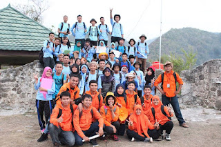
Geomorphology field work 2015 was held at Otanaha Castle, Gorontalo. Otanaha castle was built at the top of the mountains so the landform can be observed clearly The field work was followed by students of class '15 at Geography Education Major, Earth Science and Technology Department, Universitas Negeri Gorontalo.
Field work includes the identification of landforms in the field work location. Students were given the ability to use compass, read a map and plot position on a map.
This field works are supervised by Intan Noviantari Manyoe, S.Si., MT (Lecturer), Febryant Masulili (Assistant Coordinator), Nurfauziah Kadir (Vice Koas), Alifia Widya Warapsari Badaru (Assistant), Mohamad Mokoginta (Assistant), Umar Zulkarnain Bakkar (Assistant), Fajri Fitrah Fidiyanto A. Rasyid (Co-Assistant), Muhammad Iqbal Asiki (Co-Assistant), Ayub Immaduddin Mooduto (Co-Assistant), Destira Handayani Eksan (Co-Assistant) and Fitry Handayani Putje (Co-Assistant).
Assistant coordinator, Assistants, co-assistant, and students.
15/16 Gasal was done.
Bentuk Lahan Geomorfologi di Daerah Gunungapi Ambang, Bolaang Mongondow Timur
Sulawesi or Celebes is located in the central part of the Indonesian archipelago which has interesting geological potential to be developed. One of this interesting area is known as Ambang volcano area. Ambang volcano is one of the active volcanoes in North Sulawesi. Administratively, the research area is located in Bongkudai Baru Village, Modayag sub-district, East Bolaang Mongondow district, mapped at coordinates N 0°45'58.89'' and E 124°24'13.04''. This study is aimed to analyze volcanic geomorphological units using satellite imagery and surface geological mapping. The results showed that the geological conditions of the study area consist of 4 lithologies i.e volcanic breccia, andesite, agglomerate and sandstone rocks. Based on the morphographic and morphogenetic analysis of the study area which refers to the Van Zuidam and Verstapen 1985 classification, the study area is divided into five landforms i.e fumarole and solfatara ambang volcanic, ambang volcanic cone, plains and fluvial slope feet of ambang volcano, denudational hill ambang volcanoes and lake units.
Sumarjis, S. A., Arifin, Y. I., Hutagalung, R., Akase, N., & Manyoe, I. N. (2023). Bentuk Lahan Geomorfologi Di Daerah Gunungapi Ambang, Bolaang Mongondow Timur. Journal of Applied Geoscience and Engineering, 2(1), 46-56.
Geomorphological Study of the Talumopatu Geothermal Area Gorontalo Regency Gorontalo Province
Geomorphological research is urgently needed to be carried out in areas with geothermal potential such as in Talumopatu. Geomorphological analysis was chosen to complete the data in the early stages of the geothermal exploration of the study area. The purpose of this study was to determine the geomorphological characteristics of the study area. This study uses image interpretation methods and field excursions to observe the morphology of the study area. The stages of data processing use software applications based on Geographic Information Systems (GIS). The Geomorphological analysis consists of analysis of morphography, morphometry and morphogenesis. The analysis results are then compiled to produce a geomorphological map that refers to the van Zuidam classification. In accordance with the results of the analysis, it can be concluded that the geomorphological condition of the study area is divided into three parts, namely the Alluvial Plain Unit, Peneplains Unit, and Residual Hills Unit.
Hamim, R. H. P., Arifin, Y. I., & Manyoe, I. N. (2023). Geomorphological Study of the Talumopatu Geothermal Area Gorontalo Regency Gorontalo Province. In E3S Web of Conferences (Vol. 400, p. 01005). EDP Sciences.