
Geomorphological Study of the Talumopatu Geothermal Area Gorontalo Regency Gorontalo Province
Geomorphological research is urgently needed to be carried out in areas with geothermal potential such as in Talumopatu. Geomorphological analysis was chosen to complete the data in the early stages of the geothermal exploration of the study area. The purpose of this study was to determine the geomorphological characteristics of the study area. This study uses image interpretation methods and field excursions to observe the morphology of the study area. The stages of data processing use software applications based on Geographic Information Systems (GIS). The Geomorphological analysis consists of analysis of morphography, morphometry and morphogenesis. The analysis results are then compiled to produce a geomorphological map that refers to the van Zuidam classification. In accordance with the results of the analysis, it can be concluded that the geomorphological condition of the study area is divided into three parts, namely the Alluvial Plain Unit, Peneplains Unit, and Residual Hills Unit.
Hamim, R. H. P., Arifin, Y. I., & Manyoe, I. N. (2023). Geomorphological Study of the Talumopatu Geothermal Area Gorontalo Regency Gorontalo Province. In E3S Web of Conferences (Vol. 400, p. 01005). EDP Sciences.
Geology and Geophysics of Talumopatu Geothermal Manifestation Area of Mootilango District Gorontalo Regency Indonesia
The research aims to assess the geothermal potential and provide a better understanding of the geology and geophysics of the area. The study utilizes various methods, including geological mapping, geochemical analysis, and magnetic and electromagnetic data analysis, to gain insights into the subsurface structures and characteristics of the geothermal system. The study area can be divided into three geomorphological units: Alluvial Plain Unit, Near Plains Unit, and Isolated Hill Unit. The study area exhibits a stratigraphy consisting of three primary units: Talumopatu granite units, Talumopatu sandstone units, and alluvial deposit units. The subsurface lithologies of the Talumopatu manifestation area were analyzed using the Wenner – Alpha configuration ERT method, revealing two distinct lithologies. The first lithology consists of sandstones with a resistivity value ranging from 4.2 to 39.0 ohm.m and a thickness of 1.25 to 12.4 m, which act as a permeable layer capable of transmitting water. The second lithology is granite with a resistivity value ranging from 118 to 360 ohm.m and a thickness of 3.75 to 15.9 m. This information provides valuable insights into the subsurface characteristics of the area, including the presence of permeable layers and the geological composition of the lithologies.
Ayu, D., Arifin, Y. I., Zainuri, A., Manyoe, I. N., & Jahja, M. (2023). Geology and Geophysics of Talumopatu Geothermal Manifestation Area of Mootilango District, Gorontalo Regency, Indonesia. In E3S Web of Conferences (Vol. 400, p. 01013). EDP Sciences.
Hydrogeology Fieldwork in Gorontalo Geothermal Area
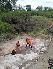
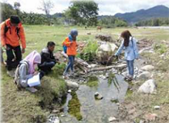
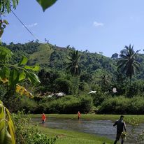
Hydrogeology field work 2015 was held at four location in Gorontalo. The field work was followed by students of class '12 (Geohazard) and students of class '13 (Geobaper & Geoamnesia) at Geological Engineering Major, Earth Science and Technology Department, Universitas Negeri Gorontalo.
Field work includes the identification of geothermal hydrogeology in the field work location. Students observed the morphology, stratigraphy, water table, and physical-chemistry of hot springs in field work location. This field works are supervised by Intan Noviantari Manyoe, S.Si., MT (Lecturer).
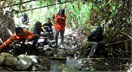
Picture 1. Hydrogeology field work at Lombongo.
Picture 2. Hydrogeology field work at Pancuran.
Picture 3. Hydrogeology field work at Pangi.
Picture 4. Hydrogeology field work at Pentadio.
14/15 Genap was done.
Kajian Geologi Bawah Permukaan Daerah Geotermal Bongongoayu, Kecamatan Boliyohuto, Kabupaten Gorontalo, Provinsi Gorontalo
Kegiatan lapangan (sumber: Lia Elviyanti).
Daerah penelitian secara administratif berada di Kecamatan Boliyohuto, Kabupaten Gorontalo, secara fisiografi daerah penelitian berada di lembah paguyaman yang didominasi oleh batuan gunungapi dan endapan danau. Penelitian ini bertujuan untuk mengetahui geologi bawah permukaan daerah Bongonggoayu. Metode yang digunakan dalam penelitian ini menggunakan geolistrik konfigurasi Wenner-Sclumberger. Hasil penelitian geologi bawah permukaan daerah penelitian menggunakan geolistrik Wenner-Schlumberger terbagi atas 4 lintasan berdasarkan pengolahan Res2dinv dan rockword terdapat beberapa lapisan litologi berdasarkan penampang 2D bawah permukaan dimana didominasi oleh lapisan kelompok batupasir, lempung dan pasir kerikil. Kemudian terdapat anomali yang kemungkinan besar pada anomali ini terdapat pengaruh struktur dengan arah barat laut-Tenggara pada lintasan 1 dan lintasan 4.
Elviyanti, L., Maryati, S., & Manyoe, I. N. (2022). Kajian Geologi Bawah Permukaan Daerah Geotermal Bongongoayu, Kecamatan Boliyohuto, Kabupaten Gorontalo, Provinsi Gorontalo. JRST (Jurnal Riset Sains dan Teknologi), 6(2), 125-130.