
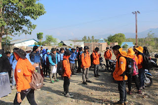
Geology Fieldwork in Suwawa Timur
Geomorphology field work 2015 was held at Suwawa Timur, Gorontalo. The field work was followed by students of class '13 at Geography Education Major, Earth Science and Technology Department, Universitas Negeri Gorontalo.
Field work includes the identification of lithology, structural geology, hazards and mineral resources potential in the field work location. Students were given the ability to use compass, read a map and plot position on a map.
This field works are supervised by Intan Noviantari Manyoe, S.Si., MT (Lecturer), Febryant Masulili (Assistant Coordinator), Nurfauziah Kadir (Vice Koas), Alifia Widya Warapsari Badaru (Assistant), Mohamad Mokoginta (Assistant), Umar Zulkarnain Bakkar (Co-Assistant), Fajri Fitrah Fidiyanto A. Rasyid (Co-Assistant), Muhammad Iqbal Asiki (Co-Assistant), Ayub Immaduddin Mooduto (Co-Assistant), Destira Handayani Eksan (Co-Assistant) and Fitry Handayani Putje (Co-Assistant).
Lecturer, assistant, co-assistant, and students.
15/16 Gasal was done.
Geomorphology Fieldwork in Otanaha
Geomorphology field work 2015 was held at Otanaha Castle, Gorontalo. Otanaha castle was built at the top of the mountains so the landform can be observed clearly The field work was followed by students of class '15 at Geography Education Major, Earth Science and Technology Department, Universitas Negeri Gorontalo.
Field work includes the identification of landforms in the field work location. Students were given the ability to use compass, read a map and plot position on a map.
This field works are supervised by Intan Noviantari Manyoe, S.Si., MT (Lecturer), Febryant Masulili (Assistant Coordinator), Nurfauziah Kadir (Vice Koas), Alifia Widya Warapsari Badaru (Assistant), Mohamad Mokoginta (Assistant), Umar Zulkarnain Bakkar (Assistant), Fajri Fitrah Fidiyanto A. Rasyid (Co-Assistant), Muhammad Iqbal Asiki (Co-Assistant), Ayub Immaduddin Mooduto (Co-Assistant), Destira Handayani Eksan (Co-Assistant) and Fitry Handayani Putje (Co-Assistant).
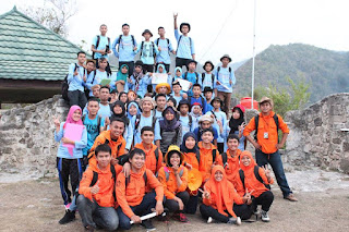
Assistant coordinator, Assistants, co-assistant, and students.
15/16 Gasal was done.
Physical Geology Fieldwork in Buli'ide
Physical Geology fieldwork 2015 was held at Buli'ide, Gorontalo. The field work was followed by students of class '15 (Geotallent) at Geological Engineering Major, Earth Science and Technology Department, Universitas Negeri Gorontalo.
Fieldwork includes the identification of physical geology in the Buli'ide. Students were given the ability to use compass, read a map, introduction to rocks and geological structures, and plot position on a map.
This field works are supervised by Intan Noviantari Manyoe, S.Si., MT (Lecturer), Febryant Masulili (Assistant Coordinator), Nurfauziah Kadir (Vice Koas), Alifia Widya Warapsari Badaru (Assistant), Mohamad Mokoginta (Assistant), Umar Zulkarnain Bakkar (Co-Assistant), Fajri Fitrah Fidiyanto A. Rasyid (Co-Assistant), Muhammad Iqbal Asiki (Co-Assistant), Ayub Immaduddin Mooduto (Co-Assistant), Destira Handayani Eksan (Co-Assistant) and Fitry Handayani Putje (Co-Assistant).
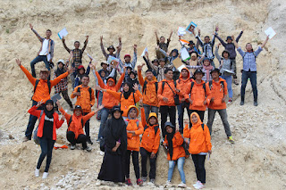
Lecturer, assistant, co-Assistant, and Geology students near from Limboto Lake.
15/16 Gasal was done.
Geophysics Fieldwork in Suwawa Timur
Geophysics fieldwork 2015 was held in Suwawa Timur, Gorontalo. The fieldwork was followed by students of class '14 (Geospan) at Geological Engineering Major, Earth Science and Technology Department, Universitas Negeri Gorontalo.
Fieldwork includes the identification of subsurface in the fieldwork location using geophysical instrumentation. Students were given the ability to use Resistivity Meter. The acquisition data using Schlumberger Configuration. They also observed the morphology, and stratigraphy in fieldwork location.
This fieldworks are supervised by Intan Noviantari Manyoe, S.Si., MT (Lecturer), and Andri Saputra Jusuf (Assistant).
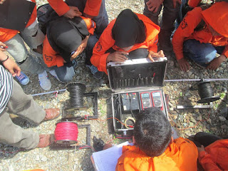
Data acquisition in the field.
15/16 Gasal was done.
Karakteristik Batuan Dasar Formasi Gabro Daerah Keramat Kabupaten Boalemo
Secara administratif wilayah penelitian terletak di Desa Keramat dan sekitarnya, Kabupaten Boalemo, Provinsi Gorontalo. Daerah penelitian tersususun oleh batuan terobosan dari formasi Batuan Gabro (Teog), Formasi Batuan Granodiorit Bumbulan (Tpb) dan Formasi Aluvium (Qal). Kondisi geologi daerah penelitian sangat kompleks sehingga menarik diteliti karena belum pernah dilakukan penelitian secara detail. Tujuan penelitian yang akan dicapai adalah mengetahui karakteristik mineralogi dan tekstur serta proses terbentuknya batuan dasar berdasarkan data pemetaan geologi dan data petrografi. Metode penelitian yang digunakan untuk mencapai tujuan penelitian tersebut terdiri dari survei geologi lapangan, penelitian laboratorium, dan pengolahan studio. Metode observasi lapangan adalah metode yang berfokus pada pengamatan kondisi geologi di daerah penelitian. Kemudian data-data yang diperoleh dianalisis menggunakan metode penelitian laboratorium berupa analisis petrografi dengan sayatan tipis. Hasil penelitian menunjukkan bahwa Morfologi daerah penelitian terbagi menjadi 2 satuan yaitu satuan perbukitan rendah struktural dan dataran aluvial. Stratigrafi daerah penelitian dibagi menjadi 2 satuan diurutkan dari tua ke muda yaitu satuan gabro, satuan granodiorite dan satuan endapan aluvial. Struktur geologi yang bekerja pada daerah penelitian berupa kekar gerus yang memiliki arah barat laut-tenggara hingga timur laut-barat daya. Berdasarkan hasil analisis petrografi yang telah dilakukan maka diperoleh hasil karateristik batuan gabro sebagai batuan dasar pada formasi gabro adalah berwarna putih kecokelatan (PPl), berwarna abu-abu hingga orange (XPL), hypokristalin, ukuran kristal (1-3 mm), bentuk dan hubungan antar kristal subhedral. Tekstur umum ekuigranular faneritik dengan komposisi mineral penyusun batuan yaitu plagioklas, K-feldspar, biotit, piroksen, mineral opak dan mineral alterasi penyusun batuan serisit. Batuan ini merupakan bagian dari jalur magmatisme pada zaman Eosen.
Damogalad, Y., Permana, A. P., Hutagalung, R., & Manyoe, I. N. (2024). Karakteristik Batuan Dasar Formasi Gabro Daerah Keramat Kabupaten Boalemo. JRST (Jurnal Riset Sains dan Teknologi), 8(1), 81-87.