
Energy and Exergy Efficiency of Water-Based Photovoltaic Thermal (PVT) Systems: An Overview
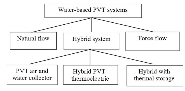
Classifications of flow pattern in water-based PVT systems.
Conventional fuels are not free, scarce and expensive, and its future cost and availability are uncertain. Hence, the usage of solar energy in applications will probably increase and further become economically feasible in the near future. Solar energy is free, clean, and renewable and has been widely used in electricity generation and thermal energy via photovoltaic thermal (PVT) system. PVT is a hybrid system consists of a PV panel and a solar collector in a single unit to simultaneously produce electricity and thermal energy. In this review, energy and exergy efficiency for water-based PVT systems is presented. As conclusion, the study on exergy is still limited and is recommended to be furthered in order to obtained useful energy generation by the system.
Rukman, N. S. B., Fudholi, A., Taslim, I., Indrianti, M. A., Manyoe, I. N., Lestari, U., & Sopian, K. (2019). Energy and Exergy Efficiency of Water-Based Photovoltaic Thermal (PVT) Systems: An Overview. Int J Pow Elec & Dri Syst, 10(2), 987-994.
Subsurface Structure Identification in Ilotidea Using Electrical Method for Developed the Flood Tourist Science Village
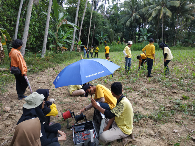
Electrical data collection.
Gorontalo is one area that is very vulnerable to flooding. Flood problems in Gorontalo must have a solution that can have a positive impact on the community and the government. The purpose of this research is to identification subsurface structure of the Ilotidea Region by using resistivity method. The result of this research will be used for the fundamental of developing the Flood Tourist Science Village. The method that used in this research is to take subsurface data by using the IPMGEO-4200 Electrical Resistivity Meter in 6 points at Ilotidea Village. Processing data through calculating the apparent resistivity (ρa) by entering the values ?V, I, R and K, then interpreting the subsurface structure of the Ilotidea region. Based on the results of the data analysis, there are obtained 5 layers at each data retrieval point. The layers found at each point are composed of sandy clay, clay, sand, clay, and sandstone. Based on the results of the interpretation of the subsurface structure, the sandy clay layer is arranged with a layer of clay which has the characteristic of not easily escaping the water. This causes the Ilotidea area to be very vulnerable to flooding because when surface runoff and rainfall falls into this area has a high intensity and volume it will cause inundation due to the absence of water absorbed by material found below the surface. Based on the subsurface structure of the Ilotidea region, the house foundation that will be made in a flood tourism science village must reach a depth of 5-10 m where at this depth the layer is a clay layer which is not easy to escape and elastic so the house is not easy to collapse.
Keywords: Lithology, Subsurface, Electrical, Flood Tourism, Ilotidea.
Tolodo, D. D., Suma, M. D., Yusuf, N. J., & Manyoe, I. N. (2019). Subsurface Structure Identification in Ilotidea Using Electrical Method for Developed the Flood Tourist Science Village. Jurnal Sains Informasi Geografi, 2(1), 44-49.
Survey and Efforts to Improve Mitigation Ability for Disability Students in Gorontalo City
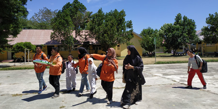
Survey at SDLB Kota Gorontalo.
The condition of Gorontalo City has a high level of vulnerability to earthquake hazards, for this reason an understanding of earthquakes needs to be done early, especially for children with disabilities. This study aims to determine the level of understanding of earthquake mitigation for students with disabilities in SDLB Gorontalo, especially the blind, deaf, and autism and to find the efforts to improve the mitigation ability of disability students. The method that will be used in this study is the survey method with the instrument used in the form of a questionnaire. The samples in this study were 34 people with disabilities in SDLB of Gorontalo City consisting of blind, deaf and autism students. The results obtained are the level of understanding and ability of students for earthquake mitigation is very low (not good category) where for blind people is 3.5%, while deaf is 1.6%, and autism is 0.1%. For this reason, efforts need to be done to improve the ability of disabilities with cheerful learning media such as cheerful music for the visually impaired, attractive images for the deaf, and for autism given attractive images accompanied by gifts for what they do to improve their abilities and their learning enthusiasm.
Keywords: Disability , Students, Ability, Earthquake, Mitigation, Gorontalo.
Duwingik, R. F., Ayu, D. A., Dano, M. A., & Manyoe, I. N. (2019). Survey and Efforts to Improve Mitigation Ability for Disability Students in Gorontalo City. Jurnal Sains Informasi Geografi, 2(1), 40-43.
Geologi Daerah Geothermal Pangi Kabupaten Bone Bolango Provinsi Gorontalo

Geology data collection.
Geothermal is associated with volcanic that still has heat energy below the surface. Indonesia is a country with geothermal energy reserves of around 40%. There are 256 potential geothermal areas and only 7 locations have been utilized. Gorontalo has several geothermal manifestations, such as Lombongo, Pangi, Libungo, and Hungayono. The purpose of this study was to study the geology of the geothermal manifestations of Pangi, East Suwawa District, Bone Bolango Regency, Gorontalo Province. The research method is divided into field observations, laboratory analysis, and studio analysis. The results of this research show that the geomorphology in the study area is divided into 3 units, namely the Fluvial Plain, the Volcanic Hills, and the Structural Use Landscape. Alluvial Deposition Unit, Volcanic Breccia Unit, Tuff Lapili Unit, Andesite Unit, Granodiorite Unit, and Porphyry Diorite Unit.
Keywords: Geology, Gorontalo, Manifestasi Geothermal, Pangi.
Tolodo, D. D., Usman, F. C. A., Manyoe, I. N., Gaib, F. A., Putje, F. H., & Ibrahim, Y. (2019). Geologi Daerah Geothermal Pangi Kabupaten Bone Bolango Provinsi Gorontalo. Jambura Geoscience Review, 1(1), 22-29.
Geologi Daerah Dimito dan Sekitarnya Kabupaten Boalemo Provinsi Gorontalo
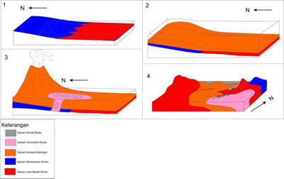
Reconstruction of geologic history of Dimito (Badaru, 2019).
Administratively, the research area covers two districts, Wonosari Sub-district and Dulupi Sub-district, Boalemo District, Gorontalo Province. Based on the physiography of the Gorontalo region, the research area which is included in the southern mountain zone of Bone-Tilamuta-Modello generally consists of ancient volcano-sedimentary rock formations in Gorontalo, the Eocene-Oligocene. The purpose of this geological research is to discover the geological order that developed in the area of Dimito and surrounding are as covering several aspect such as geomorphology, stratigraphy, geological structure, and geological history. The result shows that the geomorphology of the research area divided into three geomorphic units, namely the units of the Alluvial Plain, Volcanic Hills, and Denudasional Hills. Stratigraphy of the research area divided into five types of units sorted from the early Miocene to the Holocene, i.e., Lava Basal Dimito (Early Eocene), Wackestone Dimito (Early Eocene), Andesit Kalidingin (Middle Miocene), Granodiorite Bualo (Middle Pliocene), and Alluvial Buaolo (Recen). Geological structures that work on the location of the research area relatively trend from northeast-southwest to northwest-southeast. Fault working on the location of the research area from the data processing consists of Normal Left Slip Fault Kalidingin and Lag Left Slip Fault Bualo.
Keywords: Boalemo, Dimito, Geology, Gorontalo, Stratigraphy, Structure.
Badaru, A. W. W., Lihawa, F., & Manyoe, I. N. (2019). Geologi Daerah Dimito dan Sekitarnya Kabupaten Boalemo Provinsi Gorontalo. Jambura Geoscience Review, 1(1), 13-21.