
Survey and Efforts to Improve Mitigation Ability for Disability Students in Gorontalo City
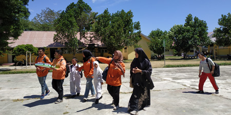
Survey at SDLB Kota Gorontalo.
The condition of Gorontalo City has a high level of vulnerability to earthquake hazards, for this reason an understanding of earthquakes needs to be done early, especially for children with disabilities. This study aims to determine the level of understanding of earthquake mitigation for students with disabilities in SDLB Gorontalo, especially the blind, deaf, and autism and to find the efforts to improve the mitigation ability of disability students. The method that will be used in this study is the survey method with the instrument used in the form of a questionnaire. The samples in this study were 34 people with disabilities in SDLB of Gorontalo City consisting of blind, deaf and autism students. The results obtained are the level of understanding and ability of students for earthquake mitigation is very low (not good category) where for blind people is 3.5%, while deaf is 1.6%, and autism is 0.1%. For this reason, efforts need to be done to improve the ability of disabilities with cheerful learning media such as cheerful music for the visually impaired, attractive images for the deaf, and for autism given attractive images accompanied by gifts for what they do to improve their abilities and their learning enthusiasm.
Keywords: Disability , Students, Ability, Earthquake, Mitigation, Gorontalo.
Duwingik, R. F., Ayu, D. A., Dano, M. A., & Manyoe, I. N. (2019). Survey and Efforts to Improve Mitigation Ability for Disability Students in Gorontalo City. Jurnal Sains Informasi Geografi, 2(1), 40-43.
Geologi Daerah Geothermal Pangi Kabupaten Bone Bolango Provinsi Gorontalo

Geology data collection.
Geothermal is associated with volcanic that still has heat energy below the surface. Indonesia is a country with geothermal energy reserves of around 40%. There are 256 potential geothermal areas and only 7 locations have been utilized. Gorontalo has several geothermal manifestations, such as Lombongo, Pangi, Libungo, and Hungayono. The purpose of this study was to study the geology of the geothermal manifestations of Pangi, East Suwawa District, Bone Bolango Regency, Gorontalo Province. The research method is divided into field observations, laboratory analysis, and studio analysis. The results of this research show that the geomorphology in the study area is divided into 3 units, namely the Fluvial Plain, the Volcanic Hills, and the Structural Use Landscape. Alluvial Deposition Unit, Volcanic Breccia Unit, Tuff Lapili Unit, Andesite Unit, Granodiorite Unit, and Porphyry Diorite Unit.
Keywords: Geology, Gorontalo, Manifestasi Geothermal, Pangi.
Tolodo, D. D., Usman, F. C. A., Manyoe, I. N., Gaib, F. A., Putje, F. H., & Ibrahim, Y. (2019). Geologi Daerah Geothermal Pangi Kabupaten Bone Bolango Provinsi Gorontalo. Jambura Geoscience Review, 1(1), 22-29.
Geologi Daerah Dimito dan Sekitarnya Kabupaten Boalemo Provinsi Gorontalo
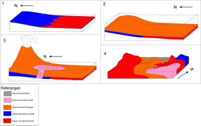
Reconstruction of geologic history of Dimito (Badaru, 2019).
Administratively, the research area covers two districts, Wonosari Sub-district and Dulupi Sub-district, Boalemo District, Gorontalo Province. Based on the physiography of the Gorontalo region, the research area which is included in the southern mountain zone of Bone-Tilamuta-Modello generally consists of ancient volcano-sedimentary rock formations in Gorontalo, the Eocene-Oligocene. The purpose of this geological research is to discover the geological order that developed in the area of Dimito and surrounding are as covering several aspect such as geomorphology, stratigraphy, geological structure, and geological history. The result shows that the geomorphology of the research area divided into three geomorphic units, namely the units of the Alluvial Plain, Volcanic Hills, and Denudasional Hills. Stratigraphy of the research area divided into five types of units sorted from the early Miocene to the Holocene, i.e., Lava Basal Dimito (Early Eocene), Wackestone Dimito (Early Eocene), Andesit Kalidingin (Middle Miocene), Granodiorite Bualo (Middle Pliocene), and Alluvial Buaolo (Recen). Geological structures that work on the location of the research area relatively trend from northeast-southwest to northwest-southeast. Fault working on the location of the research area from the data processing consists of Normal Left Slip Fault Kalidingin and Lag Left Slip Fault Bualo.
Keywords: Boalemo, Dimito, Geology, Gorontalo, Stratigraphy, Structure.
Badaru, A. W. W., Lihawa, F., & Manyoe, I. N. (2019). Geologi Daerah Dimito dan Sekitarnya Kabupaten Boalemo Provinsi Gorontalo. Jambura Geoscience Review, 1(1), 13-21.
Earthquake Damage Level of Gorontalo Area Based on Seismicity and Peak Ground Acceleration
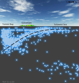
Cross section of earthquake depth of Gorontalo and surrounding area (Manyoe, 2019).
Gorontalo is located at the macro and micro plate boundary, therefore it is located in an active seismotectonic region. This study aims to analyze earthquake damage level in Gorontalo based on seismicity and peak ground acceleration. The data used is obtained from the USGS. Data is made into a database and plotted onto a geological map. Calculation of peak ground acceleration is obtained using the Kawashumi formula. The results of this study indicate that Gorontalo is included in the slight to moderate earthquake damage level because it is dominated by shallow to intermediate earthquakes depth, light to moderate earthquake magnitude, and have a peak ground acceleration 1,462 - 99,714 gal.
Keywords: Seismicity, Peak Ground Acceleration, Earthquake, Gorontalo.
Manyoe, I. N., Arif, S., & Lahay, R. J. (2019). Earthquake Damage Level of Gorontalo Area Based on Seismicity and Peak Ground Acceleration. Jambura Geoscience Review, 1(1), 7-12.
Geologi Ilotidea dan Kampung Sains Wisata Banjir
Buku Geologi Ilotidea dan Kampung Sains Wisata Banjir.
Buku Geologi Ilotidea dan Kampung Sains Wisata Banjir membahas tentang geologi, geomorfologi, geofisika dan fenomena banjir di daerah Ilotidea serta solusi tentang Kampung Sains Wisata Banjir untuk daerah Ilotidea. Adalah hal yang mainstream dalam masyarakat untuk mengungsi dan menunggu bantuan pemerintah saat terjadi banjir. Buku Geologi Ilotidea dan Kampung Sains Wisata Banjir menghadirkan sebuah pemikiran dan solusi yang tidak lagi melihat banjir sebagai bencana tapi sebagai sumber pendapatan masyarakat melalui pengembangan kampung sains wisata banjir.
Tolodo, D. D., Suma, M. D., Yusuf, N. J., & Manyoe, I. N. (2019). Geologi Ilotidea dan Kampung Sains Wisata Banjir. UNG Press, Gorontalo.