
Geologi Daerah Dimito dan Sekitarnya Kabupaten Boalemo Provinsi Gorontalo
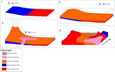
Reconstruction of geologic history of Dimito (Badaru, 2019).
Administratively, the research area covers two districts, Wonosari Sub-district and Dulupi Sub-district, Boalemo District, Gorontalo Province. Based on the physiography of the Gorontalo region, the research area which is included in the southern mountain zone of Bone-Tilamuta-Modello generally consists of ancient volcano-sedimentary rock formations in Gorontalo, the Eocene-Oligocene. The purpose of this geological research is to discover the geological order that developed in the area of Dimito and surrounding are as covering several aspect such as geomorphology, stratigraphy, geological structure, and geological history. The result shows that the geomorphology of the research area divided into three geomorphic units, namely the units of the Alluvial Plain, Volcanic Hills, and Denudasional Hills. Stratigraphy of the research area divided into five types of units sorted from the early Miocene to the Holocene, i.e., Lava Basal Dimito (Early Eocene), Wackestone Dimito (Early Eocene), Andesit Kalidingin (Middle Miocene), Granodiorite Bualo (Middle Pliocene), and Alluvial Buaolo (Recen). Geological structures that work on the location of the research area relatively trend from northeast-southwest to northwest-southeast. Fault working on the location of the research area from the data processing consists of Normal Left Slip Fault Kalidingin and Lag Left Slip Fault Bualo.
Keywords: Boalemo, Dimito, Geology, Gorontalo, Stratigraphy, Structure.
Badaru, A. W. W., Lihawa, F., & Manyoe, I. N. (2019). Geologi Daerah Dimito dan Sekitarnya Kabupaten Boalemo Provinsi Gorontalo. Jambura Geoscience Review, 1(1), 13-21.
Earthquake Damage Level of Gorontalo Area Based on Seismicity and Peak Ground Acceleration
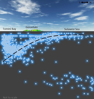
Cross section of earthquake depth of Gorontalo and surrounding area (Manyoe, 2019).
Gorontalo is located at the macro and micro plate boundary, therefore it is located in an active seismotectonic region. This study aims to analyze earthquake damage level in Gorontalo based on seismicity and peak ground acceleration. The data used is obtained from the USGS. Data is made into a database and plotted onto a geological map. Calculation of peak ground acceleration is obtained using the Kawashumi formula. The results of this study indicate that Gorontalo is included in the slight to moderate earthquake damage level because it is dominated by shallow to intermediate earthquakes depth, light to moderate earthquake magnitude, and have a peak ground acceleration 1,462 - 99,714 gal.
Keywords: Seismicity, Peak Ground Acceleration, Earthquake, Gorontalo.
Manyoe, I. N., Arif, S., & Lahay, R. J. (2019). Earthquake Damage Level of Gorontalo Area Based on Seismicity and Peak Ground Acceleration. Jambura Geoscience Review, 1(1), 7-12.
Geologi Ilotidea dan Kampung Sains Wisata Banjir
Buku Geologi Ilotidea dan Kampung Sains Wisata Banjir.
Buku Geologi Ilotidea dan Kampung Sains Wisata Banjir membahas tentang geologi, geomorfologi, geofisika dan fenomena banjir di daerah Ilotidea serta solusi tentang Kampung Sains Wisata Banjir untuk daerah Ilotidea. Adalah hal yang mainstream dalam masyarakat untuk mengungsi dan menunggu bantuan pemerintah saat terjadi banjir. Buku Geologi Ilotidea dan Kampung Sains Wisata Banjir menghadirkan sebuah pemikiran dan solusi yang tidak lagi melihat banjir sebagai bencana tapi sebagai sumber pendapatan masyarakat melalui pengembangan kampung sains wisata banjir.
Tolodo, D. D., Suma, M. D., Yusuf, N. J., & Manyoe, I. N. (2019). Geologi Ilotidea dan Kampung Sains Wisata Banjir. UNG Press, Gorontalo.
Belajar Gempa Ceria
Buku Braille Belajar Gempa Ceria.
Gempa adalah hentakan asli dari kulit bumi yang terjadi karena adanya pergerakan lempeng dan sesar aktif. Mitigasi bencana gempa adalah salah satu upaya untuk mengurangi jatuhnya korban jiwa akibat terjadinya gempa. Sampai saat ini gempa belum dapat diprediksi tempat dan waktu kejadiannya. Agar tidak jatuh korban jiwa maka yang dapat dilakukan adalah upaya mitigasi. Buku Belajar Gempa Ceria disusun untuk memberikan pengenalan mengenai gempa dan langkah-langkah mitigasi yang dapat dilakukan saat dan setelah terjadi gempa. Buku Belajar Gempa Ceria merupakan buku braille kegempaan yang ditujukan buat penyandang tuna netra terutama anak-anak agar memiliki kemampuan mitigasi bila terjadi bencana gempa, juga buat para guru dan orangtua agar dapat mengajarkan dan menerapkannya di sekolah dan rumah.
Duwingik, R. F., Kasim, D.N.P., Ayu, D., Dano, M. A., & Manyoe, I. N. (2019). Belajar Gempa Ceria. UNG Press, Gorontalo.
Rekonstruksi Tipe Longsoran di Daerah Gorontalo Outer Ring Road (GORR) dengan Analisis Stereografi
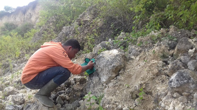
Structure data collection (Usman, 2018).
Gorontalo Province development target focused for transportation network efficiency. This development planned to be completed in 2019 but there is a problem caused by landslides. One of the solution for this is landslide problem is to identified the landslide type and identified the landslide failure plane. This study aims to reconstruct the landslide and to identify the the failure plane at GORR (Gorontalo Outer Ring Road) using field geological method and stereography analysis. Geological methods used to interpret lithological data, geomorphological, and geological structures data, especially the discontinuity planes in the research area. The studio analysis consists of processing and interpreting discontinuity data to reconstruct types of landslides in the study area. The results showed that the geomorphic unit of the research area is a denudational hills which is composed of limestone reef formation. The measurement of geological structures reveals that the direction of the main stress regime is relatively east-west with dip direction relative to the South. The position of the failure plane is N 126oE / 21o SW. The result of this type of landslide indicates plane failure type with sliding movement. One way of countermeasures prevention can be doing by dredging the avalanche material and making the landslide prevention wall along the landslide.
Keywords: Reconstruction, Landslide, Stereographic, Plane Failure.
Usman, F.C.A., Manyoe, I.N., Duwingik, R.F., Kasim, D.N.P. 2018. Rekonstruksi Tipe Longsoran di Daerah Gorontalo Outer Ring Road (GORR) dengan Analisis Stereografi. Jurnal Geomine. Vol. 6. No. 1.