
Geologi dan Mitigasi Gorontalo Outer Ring Road
![]()
Buku Geology dan Mitigasi GORR.
Buku ini berisi tentang pembahasan mengenai longsoran yang terjadi pada ruas jalan Gorontalo Outer Ring Geologi dan Mitigasi Gorontalo Outer Ring Road Road (GORR) dikaji dari aspek geologi dan mitigasi. Penulis berharap buku ini dapat bermanfaat dalam memberikan informasi tentang geologi dan geofisika pada daerah Gorontalo Outer Ring Road, menyelesaikan permasalahan di Gorontalo Outer Ring Road dan sebagai upaya mitigasi bencana longsor.
Usman, F.C.A., Manyoe, I.N., Duwingik, R.F., & Kasim, D.N.P. (2018). Geologi dan Mitigasi Gorontalo Outer Ring Road. UNG Press, Gorontalo.
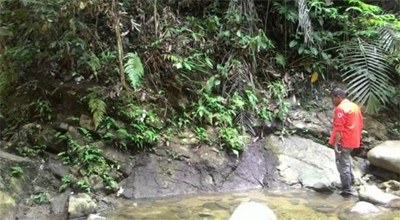
Direct Utilities of Geothermal Energy Potential in Pangi Area of Bone Bolango Regency, Gorontalo Based on Geophysical Analysis.
Pangi Geothermal research team.
Pangi is one of the areas in Bone Bolango Regency of Gorontalo which is have a geothermal manifestation point such as hot springswith surface temperature of 47-56°C. Geothermal manifestation here is not utilize yet. The purpose of this research is to use geophysicalanalysis of the electrical cross section of resistivity using Schlumberger configuration and Wenner configuration to design the utilities of geothermal energy in Pangi’s geothermal areas. The surface data gather in the field that is about the geothermal manifestation data. The subsurface data gather by using the resistivity meter with Schlumberger configuration as sounding and Wenner configuration as mapping that focus on the manifestation point. Processing data use IPI2win and Res2dinv software. The result show that there is 7 layers type of lithology which are Alluvial, Sand, Clay, Volcanic Breccia, Andesite, Granodiorite, and DioritePorphyry. The cap rock layer of Pangi’s geothermal areas is an Alluvial and the reservoir layer is aSand layer. Pangi’s geothermal manifestation is potential for the direct use in agriculture sectors, aquaculture sectors, and in the medical sectors.
Keywords: Pangi, Geothermal, Geophysics, Direct Utilities.
Usman, F.C.A., Tolodo, D.D., Manyoe, I.N., Ibrahim, Y., and Putje, F.H. 2017. Direct Utilities Of Geothermal Energy Potential In Pangi’s Area Of Bone Bolango Regency, Gorontalo Based On Geophysical Analysis. International Conference on Transdisciplinary Approach Research. Universitas Negeri Gorontalo and Ehime University Japan, Indonesia.
Petrography Volcanic Rock: Volcanic Rock Alteration Study of Colo Volcano Indonesia
Colo Volcano research team.
The existence of Colo Volcano on the southwest side of the North Arm of Sulawesi Magmatic Arc show evidence of evolutionary difference plate under Tomini Bay. Colo Volcanism activity indicated a product of slab rollback final extension of the Gulf Gorontalo. This study aims to investigate the alterated vulcanic rocks of the Colo Volcano. In this study, petrographic analysis is used to determine mineral composition based on petroscopic. Several lava and pyroclastic outcrops, indicating an alteration of the Colo Volcano product. The analysis showed andesite lava on gray-green thin incisions, subhedral-anhedral shape, mineral composition consist of hornblende (10%), biotite (10%), quartz (15%), pyroxene (10%), orthoclase (10%), Plagioclase (10%), opaque minerals (20%) and glasses (15%). The Orthoclase, is white-blueish-gray, orthorhombic, low cleavage, twinning altered look. Locally shows colorless-blue-grayish, subhedral-anhedral shape, mineral composition consisting of hornblende (10%), biotite (10%), quartz (50%), pyroxene (5%), orthoclase (5%), opaque minerals (15%) and glasses (5%). It might consist of cholorotisation of biotite. The lava exposed on Mount Ambu shows the presence of smectite alteration and pyrite mineralization, on thin incisions including blue-gray-brown, subhedral-anhedral shape, mineral composition consist of hornblende (10%), biotite (5%), quartz (10%), Olivine (5%), plagioclase (20%), orthoclase (15%), opaque minerals (15%) and glasses (20%).
Keywords: Petrography, Colo Volcano, Indonesia, volcanic rock, alteration.
Amin, A.K.M.A., Badaru, A.W.W., Manyoe, I.N., Salama, T.H., and Laseti, K.H. 2017. Petrography Volcanic Rock : Volcanic Rock Alteration Study of Colo Volcano Indonesia. International Conference on Transdisciplinary Approach Research. Universitas Negeri Gorontalo and Ehime University Japan, Indonesia.
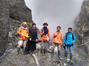
Kajian Geologi Daerah Panas Bumi Lombongo, Kabupaten Bone Bolango, Provinsi Gorontalo
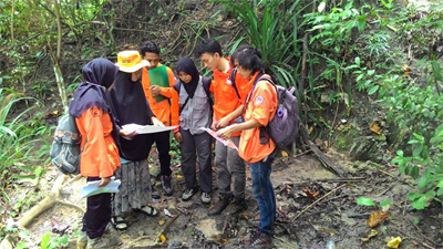
Geology data collection (Manyoe, 2017).
Bone Bolango District is an area that began to evolve so that it takes the energy supply like
geothermal energy to support development. The purpose of this study was to assess the geological conditions of the Lombongo geothermal area. The research location is at coordinates 0°32' N - 0°32'40 "N and 123°10'40"E - 123 ° 11'40" E. Studies conducted on geothermal manifestations, lithology, geomorphology, flow net, and hydrogeological of research area. Observations geothermal manifestations such as physical properties and chemical properties of hot springs. Lithology and geomorphology observations include observations of minerals and landforms. Hydrogeological observations such as flow net, recharge areas, discharge area, and the runoff area. The temperature of hot springs in the Lombongo geothermal area are 420C-480C. The appearance of the hot springs in the Lombongo controlled by strike slip fault. Lombongo geothermal area and the surrounding area consists of volcanic rocks such as andesite and diorite intrusive rocks form. Morphology Lombongo and surrounding area consists of volcanic mountains, denudational hills and denudasional fluvial plains. Recharge area is in the mountains in the northern part of the study area while the discharge area is located in the southern part of the study area. Geological studies of research area shows that the heat source is volcanic body and strike slip fault is the way of hot waters from reservoir to the surface.
Keywords: Geology, Geothermal, Lombongo, Gorontalo.
Manyoe, I.N., dan Bahutalaa, I. 2017. Kajian Geologi Daerah Panas Bumi Lombongo, Kabupaten Bone Bolango, Provinsi Gorontalo. Jurnal Geomine, Vol. 5, No. 1.
Model Inversi Data Geolistrik untuk Penentuan Lapisan Bawah Permukaan Daerah Panas Bumi Bongongoayu, Gorontalo
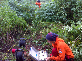
Electrical data collection.
Research areas are included in the Boliyohuto District, Gorontalo. Geothermal manifestations in the study area is a pond of hot water with surface temperatures reaching 59?C. Sounding acquisition data with Schlumberger configuration. This study aims to determine the pattern of subsurface configuration based electrical models of the data inversion. The results showed a geothermal reservoir is located on the third layer with high resistivity values >500 Ωm. Intrusive rocks which suffered a suspected fracture geothermal reservoir. Layer I is a cap rock with very low resistivity values
Keywords: Inversion, Electrical, Geothermal, Gorontalo.
Manyoe, I.N. 2016. Model Inversi Data Geolistrik untuk Penentuan Lapisan Bawah Permukaan Daerah Panas Bumi Bongongoayu, Gorontalo. Jurnal Sainstek, Vol. 8, No. 4.