
Geology and Geophysics of Talumopatu Geothermal Manifestation Area of Mootilango District Gorontalo Regency Indonesia
The research aims to assess the geothermal potential and provide a better understanding of the geology and geophysics of the area. The study utilizes various methods, including geological mapping, geochemical analysis, and magnetic and electromagnetic data analysis, to gain insights into the subsurface structures and characteristics of the geothermal system. The study area can be divided into three geomorphological units: Alluvial Plain Unit, Near Plains Unit, and Isolated Hill Unit. The study area exhibits a stratigraphy consisting of three primary units: Talumopatu granite units, Talumopatu sandstone units, and alluvial deposit units. The subsurface lithologies of the Talumopatu manifestation area were analyzed using the Wenner – Alpha configuration ERT method, revealing two distinct lithologies. The first lithology consists of sandstones with a resistivity value ranging from 4.2 to 39.0 ohm.m and a thickness of 1.25 to 12.4 m, which act as a permeable layer capable of transmitting water. The second lithology is granite with a resistivity value ranging from 118 to 360 ohm.m and a thickness of 3.75 to 15.9 m. This information provides valuable insights into the subsurface characteristics of the area, including the presence of permeable layers and the geological composition of the lithologies.
Ayu, D., Arifin, Y. I., Zainuri, A., Manyoe, I. N., & Jahja, M. (2023). Geology and Geophysics of Talumopatu Geothermal Manifestation Area of Mootilango District, Gorontalo Regency, Indonesia. In E3S Web of Conferences (Vol. 400, p. 01013). EDP Sciences.
Lineament Extraction Analysis Using Digital Elevation Model (DEM) in Lahendong Geothermal Area, North Sulawesi
Sulawesi is located in the triple junction which makes it has a high complex tectonic setting implicated for the emergence of geothermal potential. Existing geological structure near the research area is only in the top-right of the research area which far from any of the hot spring points. This research aims to analyze the lineament extraction to find out the alleged structure and the density area to determine the permeability of the Lahendong geothermal area using National Digital Elevation Model (DEMNAS) data imagery. Digital Elevation Model (DEM) data is processed using Remote Sensing Photogrammetry application to produce lineament extraction. Lineament density map is carried out using a Geographic Information System (SIG) application and then processed to generate rosette diagram. Based on the lineament extraction and lineament density analysis result, we can interpret that the Lahendong geothermal area is dominated with high density, which is interpreted as good permeability. Lineaments in the Lahendong geothermal area is northwest-southeast and almost north-south. The extracted lineament is also providing the alleged structure in the research area.
Rauf, J., Kayambo, M. R., Nurjana, I., & Manyoe, I. N. (2023). Lineament Extraction Analysis Using Digital Elevation Model (DEM) in Lahendong Geothermal Area, North Sulawesi. In E3S Web of Conferences (Vol. 400, p. 01009). EDP Sciences.
Analysis and Quantitative Assessment of Geodiversity at Karya Murni, Gorontalo, Indonesia
Karya Murni is one of the areas in the northern arm of Sulawesi that has been tectonically influenced. Tectonic processes have implications for the formation of rocks and geological features that have the potential to be developed into geodiversity sites. The development of geological features as a geodiversity site in aspiring geopark Gorontalo can protect valuable geological features from frequent degradation. This research aims to analyze and conduct quantitative assessments of geological diversity in Karya Murni, Gorontalo. The research method used is field observation, laboratory analysis, and geodiversity assessment. Field observations included observing landform, collecting rock samples, and measuring geological structures. Field observations were also carried out to observe aspects of the geodiversity assessment which included science, education, tourism, and risk degradation. Laboratory analysis consists of geomorphological analysis, petrographic analysis, and geological structure data analysis. Geodiversity assessment uses the Geological Survey Center of Indonesia assessment. The results suggest that the geomorphology of the study area can be divided into four geomorphic units-the volcanic hills, denudational hills, Karst hills, and fluvial plain units. The stratigraphy of the research area is divided into four units from the age of the early Eocene to the Holocene-the andesite lava, volcanic breccia, reef limestone, and alluvial deposit units. The geological structure of the study area is a trending northeast–southwest to northwest–southeast. Active faults at the location of the study area consist of the Apitalawu normal fault. At recent states, generally geosites of the Karya Murni have moderate scientific values, the low educational and touristic values and high risk of degradation. The geodiversity potential of the research area can be utilized for further research and education.
Arifin, Y. I., Pattiro, W. M., Manyoe, I. N., Napu, S. S. S., & Sugawara, H. (2023). Analysis and quantitative assessment of geodiversity at Karya Murni, Gorontalo, Indonesia. Geo Journal of Tourism and Geosites, 48, 763-773.
Mobile App Marketing Oluhuta Journey as A Promotion and Marketing Tool for Edu-Geotourism in Oluhuta Village
Gerbang Oluhuta Journey.
Information and communication technology has become a necessity in all aspects of life, including the tourism sector. For this reason, the team of PHP2D created an innovative application for edu-geotourism in Oluhuta Village. The method used in the community service includes the initial planning, execution stage, monitoring and evaluation stage. The results showed the application was very functional and in accordance with the edu-geotourism concept, thus made the implementation of the edugeotourism concept in Oluhuta Village more optimal, especially in helping the surrounding community to promote and market tourist attractions in Oluhuta Village. The public and visitors could use the mobile app marketing to recognize the potential exists and available local products in Oluhuta Village. On the other hand, the obstacle found that poor internet access in Oluhuta Village caused some visitors got difficult to download the application, therefore it is designed to be used offline and the download process should be done before arriving in Oluhuta Village.
Saridjan, S. A., Manyoe, I. N., Kadekoh, N. I., Khansa, D. A., Tongkodu, M. A., & Kasim, M. N. A. S. (2022). Mobile App Marketing ‘Oluhuta Journey’as A Promotion and Marketing Tool for Edu-Geotourism in Oluhuta Village. Engagement: Jurnal Pengabdian Kepada Masyarakat, 6(2), 404-420.
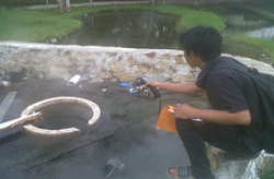
Hydrogeology Fieldwork in Gorontalo Geothermal Area
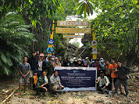
Hydrogeology field work 2015 was held at four location in Gorontalo. The field work was followed by students of class '12 (Geohazard) and students of class '13 (Geobaper & Geoamnesia) at Geological Engineering Major, Earth Science and Technology Department, Universitas Negeri Gorontalo.
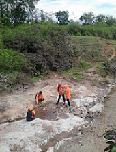
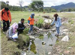
Field work includes the identification of geothermal hydrogeology in the field work location. Students observed the morphology, stratigraphy, water table, and physical-chemistry of hot springs in field work location. This field works are supervised by Intan Noviantari Manyoe, S.Si., MT (Lecturer).
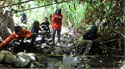
Picture 1. Hydrogeology field work at Lombongo.
Picture 2. Hydrogeology field work at Pancuran.
Picture 3. Hydrogeology field work at Pangi.
Picture 4. Hydrogeology field work at Pentadio.
14/15 Genap was done.