
Geological Structure Analysis for Potential Landslide Disaster and Mitigation at Tanjung Keramat Area, Gorontalo
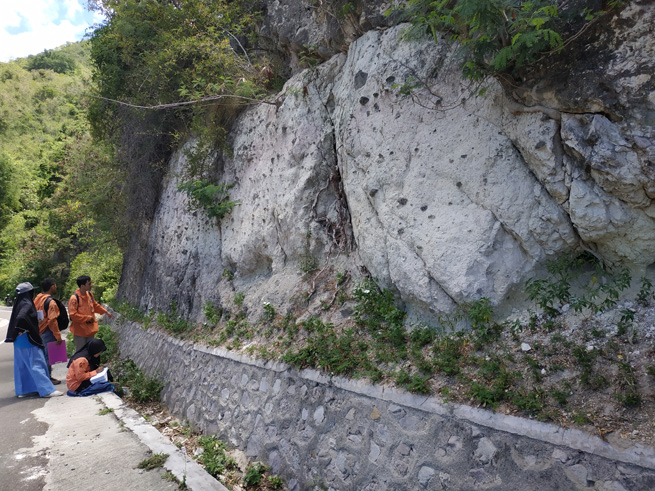
Field data collection.
Geological structures in the form of joints and faults have big role in landslide disaster. This study aims to analyze the geological structures using stereographic analysis and rosette diagrams and determine the potential landslides that can occur in the research location in order to identify landslide mitigation efforts in the research area. The method used in this research is field observations then followed by stereographic analysis and rosette diagrams, which are one of the diagrams of the presentation of orientation of the geological structures elements. The results showed that the mechanism of landslide mostly caused by the geological structures distribution in the Tanjung Keramat area, especially by joint distribution. Tension joints dominant direction relatively west as well as the slope direction. Stereographic analysis of the shear joints show the type of extensional stress directing relatively North-South. Potential types of landslide that can occur are wedge failures. Appropriate mitigation efforts are by reducing the slope angle and making structural retaining walls to withstand natural slopes and heaps high enough.
Keywords: Geology, Tuff, Joint, Wedge failure, Retaining walls.
Manyoe, I. N., Usman, F. C. A., Taslim, I., Mokoginta, M., Napu, S. S. S., & Salama, T. H. (2020). Geological Structure Analysis for Potential Landslide Disaster and Mitigation at Tanjung Keramat Area, Gorontalo. J SIG (Jurnal Sains Informasi Geografi), 3(1), 37-44.
Overview on recent photovoltaic module cooling methods: advances PVT systems
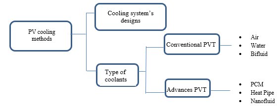
Classifications of PV cooling methods.
Renewable energy had been monopolized the research area in these past decade up till nowadays, due to its reliability and future in global production of electrical and thermal energy. Narrowing down the scope to the photovoltaic thermal (PVT) system, lots of improvements had been implied both theoretically and experimentally. One of the most attractive applications of PVT water or air-based collectors is building integrated photovoltaic thermal (BIPVT) system, which has undergone rapid developments in recent years. This review paper comprises the research findings on the improvements that had been integrated by PVT systems as well as well as personal and cited remarks on advancements on cooling techniques on PVT system.
Keywords: Renewable energy, Photovoltaic, PCM, Nanofluid, Heat pipe.
Rukman, N. S. B., Fudholi, A., Taslim, I., Indrianti, M. A., & Manyoe, I. N. (2020). Overview on recent photovoltaic module cooling methods: advances PVT systems. International Journal of Electrical and Computer Engineering, 10(1), 15.
Asesmen Nilai-Nilai Pariwisata Terhadap Fitur Geologi Daerah Bongo dan Sekitarnya Sebagai Dasar Pengembangan Geowisata di Pesisir Selatan Gorontalo
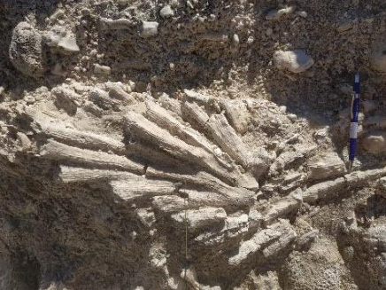
Coral limestone.
Geology is an important aspect in the development of tourism in an area. One of the attractions in a natural tourism location is certainly highly controlled by the geological setting in the area. The purpose of this research is to assess tourism values of geological features in the Bongo and surrounding areas as a basis for developing geotourism on the southern coast of Gorontalo. The research location is at coordinates N 00029’42” - N 00029’51” and E 12301’26” - E 12303’32”. The method used in this study is a surface geological survey, which includes field data collection in the form of lithology, geological structure and geomorphology. The standard used for assessing tourism values is the technical guide for assessing geological heritage resources by the Geological Survey Center. The results showed that the lithology unit of the study area consists of granite, volcanic breccia and reef limestone. The geological structure in the research area is shear fracture with main stress that relatively directed to northwest-southeast. The geomorphic unit of the study area consisted of two units, namely volcanic hills, and marine units. The results of the assessment of tourism values on geological features explain that the Bongo and surrounding areas are included in the medium category. Improvements are needed on low value criteria, namely vulnerability, relationships with other values, and economic level.
Keywords: Geotourism, Geological feature, Tourism assessment.
Septian, Y., Ndangi, W., Manyoe, I.N, Taslim, I., Umar, E., Salama, T., & Napu, S. (2019). Asesmen Nilai-Nilai Pariwisata Terhadap Fitur Geologi Daerah Bongo dan Sekitarnya Sebagai Dasar Pengembangan Geowisata di Pesisir Selatan Gorontalo. Jurnal Azimut, 2(2), 146-154.
Efficiency and energy modelling for PVT air collector with extended heat transfer area: a review
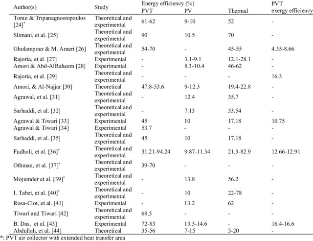
Studies conducted on PVT air collectors.
Solar energy is renewable and environment friendly and has been widely used in electricity generation and thermal energy through photovoltaic thermal (PVT) system. This system is beneficial in terms of maximum energy generation and cost of usage. The growing concern on energy sources and their usage has increased the significance and demand for PVT collectors. A PVT air collector consists of a PV panel and a thermal collector system. In PVT air collector, electricity and thermal energy are generated simultaneously. This review focuses on efficiency and energy modelling for PVT air collector with extended heat transfer area. Findings of this review indicated that PVT air collector with extended heat transfer area produced PVT efficiency higher than conventional PVT air collector. The thermal efficiency of PVT air collector for with and without extended heat transfer area are 21-83% and 12-70%, respectively, which the improvement of thermal efficiency is 15.7-42.8%.
Keywords: Renewable energy, Thermal modelling, Photovoltaic, Thermal, Solar collector.
Fudholi, A., Musthafa, M. F., Taslim, I., Indrianti, M. A., Manyoe, I. N., & Othman, M. Y. (2019). Efficiency and energy modelling for PVT air collector with extended heat transfer area: a review. Int J Pow Elec & Dri Syst Vol, 10(4), 2029-2036.
Peningkatan Pengetahuan Gempa Dan Kemampuan Mitigasi Pada Siswa Disabilitas Kota Gorontalo Melalui Program Mie Titi
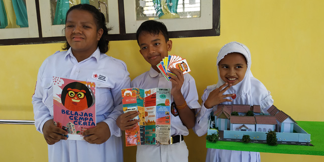
Disability students and MIE TITI media.
The condition of Gorontalo City has a high level of vulnerability to earthquake hazards, therefore understanding of earthquakes needs to be done early on, especially for children with disabilities. MIE TITI aims to increase earthquake mitigation knowledge and ability for students with disabilities at SDLB Gorontalo City, especially the visually impaired, deaf, and mentally disabled. The method to be used is a fun learning method with instruments used in the form of MINING (Music Fun Learning), MICARD (Mitigation Flascard), MINAME (Mitigation of Nature Game) and Oil and Gas (Mitigation Praise). A sample of 34 people with disabilities in Gorontalo City SDLB consisted of blind, deaf and retarded students. The results obtained are an increase in earthquake knowledge and earthquake mitigation ability in students with disabilities where in children with visual impairment by 50% and 35%, deaf by 45% and 55%, and mental retardation by 3% and 2%.
Keywords : Mitigation, Earthquake, Fun Learning, Disability, Gorontalo.
Duwingik, R. F., Della Nawarita, P. K., Dano, M. A., & Manyoe, I. N. (2019). Peningkatan Pengetahuan Gempa Dan Kemampuan Mitigasi Pada Siswa Disabilitas Kota Gorontalo Melalui Program Mie Titi. Warta Pengabdian, 13(3), 116-122.