
Peningkatan Pengetahuan Gempa Dan Kemampuan Mitigasi Pada Siswa Disabilitas Kota Gorontalo Melalui Program Mie Titi
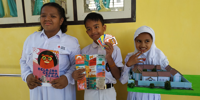
Disability students and MIE TITI media.
The condition of Gorontalo City has a high level of vulnerability to earthquake hazards, therefore understanding of earthquakes needs to be done early on, especially for children with disabilities. MIE TITI aims to increase earthquake mitigation knowledge and ability for students with disabilities at SDLB Gorontalo City, especially the visually impaired, deaf, and mentally disabled. The method to be used is a fun learning method with instruments used in the form of MINING (Music Fun Learning), MICARD (Mitigation Flascard), MINAME (Mitigation of Nature Game) and Oil and Gas (Mitigation Praise). A sample of 34 people with disabilities in Gorontalo City SDLB consisted of blind, deaf and retarded students. The results obtained are an increase in earthquake knowledge and earthquake mitigation ability in students with disabilities where in children with visual impairment by 50% and 35%, deaf by 45% and 55%, and mental retardation by 3% and 2%.
Keywords : Mitigation, Earthquake, Fun Learning, Disability, Gorontalo.
Duwingik, R. F., Della Nawarita, P. K., Dano, M. A., & Manyoe, I. N. (2019). Peningkatan Pengetahuan Gempa Dan Kemampuan Mitigasi Pada Siswa Disabilitas Kota Gorontalo Melalui Program Mie Titi. Warta Pengabdian, 13(3), 116-122.
Kajian Mitigasi Bencana Tanah Longsor Ruas Jalan Meluhu-Lasolo, Sulawesi Tenggara
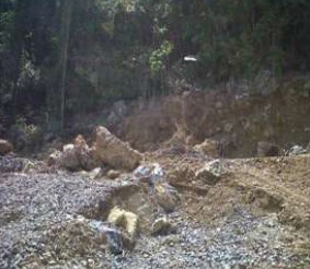
Limestone outcrop (Umar, 2019).
Geological hazards at Meluhu-Lasolo North Konawe are much more destructive when prevail can cause greater damage to lives and properties of humans when not properly and timely controlled and mitigated. This study aims to do an inventory of the types of disasters and determine all the locations that disaster-prone at Meluhu-Lasolo North Konawe Regency. The research method that will be used is an inductive method with approach combination between qualitative research and quantitative research, integrate all the literature review's results, field data, and all the results from laboratory computation research which have been reviewed, analyzed, and synthesized comprehensively. The result of this research is there is 2 (two) points of prone locations and the type of disaster is a landslide in the form of debris slide and rockfall, it is including as a high category of disaster-prone (score 4) with slope ranges from 29-850. The cause of that landslide is because that area has a steep slope, high rock weathering, cracked rock and easy to fall off, including fault line, slope that cut off by the road and vibration from all the high load vehicle that passing by, make the drainage channel defective and threatening human lives or the vehicle that passing by. There are a few things that have to do independently by the people who live there is to be more alert when rainy season come and fix all the road that have been cracked, and soil conservation.
Keywords : geology; landslide; Meluhu-Lasolo; mitigation.
Umar, E. P., Jamaluddin, J., Mustafa, M., Marnas, M. A., Manyoe, I. N., Nurfalaq, A., & Taslim, I. (2019). Kajian Mitigasi Bencana Tanah Longsor Ruas Jalan Meluhu-Lasolo, Sulawesi Tenggara. Jurnal Geocelebes, 3(2), 51-58.
Geologi dan Manifestasi Thermal Libungo

Buku Geologi dan Manifestasi Thermal Libungo.
Geotermal atau panas bumi adalah salah satu sumber energi terbarukan yang potensinya melimpah di Indonesia. Pemerintah Indonesia melalui Badan Geologi terus mendata dan meneliti potensi geotermal di seluruh wilayah Indonesia. Penelitian terhadap potensi geotermal juga dilakukan oleh para peneliti di perguruan tinggi. Buku ini membahas kondisi geologi dan manifestasi termal di daerah Libungo, Kabupaten Bone Bolango. Pembahasan difokuskan pada manifestasi termal, stratigrafi, struktur geologi, geomorfologi dan hidrogeologi daerah Libungo.
Manyoe, IN. (2019). Geologi dan Manifestasi Thermal Libungo. UNG Press, Gorontalo.
Analisis Banjir Daerah Ilotidea Kabupaten Gorontalo Menggunakan Data Citra Radar SRTM
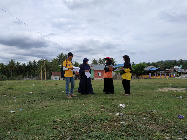
Ilotidea radar research team.
Floods are natural disasters that often occur in Indonesia, one of them in Gorontalo Province. Flood handling must begin with an understanding of flooding and geological conditions that have the potential to cause flooding. This study aims to determine the causes of flooding that occurred in the Ilotidea area based on the analysis of SRTM radar image data. SRTM data is processed and produces a 3D watershed hydrology surface model. Hydrological modeling is then carried out to obtain a 3D hydrological model on the surface of the Ilotidea region and its surroundings. Analysis of 3D watershed hydrology models and 3D hydrological models on the surface of the Ilotidea region and beyond to determine the causes of flooding in the Ilotidea region. Based on SRTM data, Ilotidea region consists of mountains morphology and lake plains. Surface modeling of 3D watershed hydrology shows that the Ilotidea region is in the Bolango watershed. The hydrological 3D surface model of the Ilotidea region shows that the flooding was caused by the overflow of Limboto Lake and Bolango River. Based on the results of the study, it can be concluded that when high-intensity rain occurs it will cause Limboto Lake and Bolango River to overflow, then causing flooding in the Ilotidea area.
Keywords: Flood, Radar, Hydrology, Gorontalo.
Tolodo, D. D., Suma, M. D., Yusuf, N. J., & Manyoe, I. N. (2019). Analisis Banjir Daerah Ilotidea Kabupaten Gorontalo Menggunakan Data Citra Radar SRTM. Jurnal Azimut, 2(1), 60-64.
Analisis Stratigrafi dan Rumusan Sejarah Geologi Daerah Limbato Dan Sekitarnya, Kabupaten Gorontalo Utara, Provinsi Gorontalo
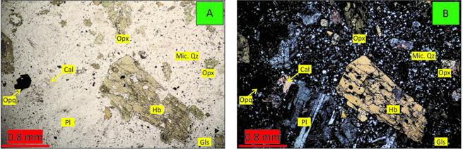
Micrograph of Granodiorite (Rahman, 2019).
Regionally, the research area is composed of volcanic and plutonic rocks. Stratigraphic data of the study area are still regional scale. This study aims to analyze detailed stratigraphic data and formulate the geological history of the Limbato area and its surroundings. The area located at coordinates 0º56’6” - 1º0’10.8” N dan 122º5’56.4” - 122º9’10.8” E, the area of the study is around 45 km². The method used in the research is scientific exploration by conducting a surface geological mapping survey. The geological surface in the form of field data collection and laboratory analysis. Field data in the form of lithology data and laboratory analysis in the form of petrology and petrographic analysis. The stratigraphy of the research area is divided into 4 (four) unofficial units, which are sorted from old to young, namely granodiorite units of Middle Miocene age, volcanic breccia units of Late Miocene to Early Pliocene, andesite units of Middle Pliocene and alluvial units of Holocene age.Stratigraphic analysis of the Limbato area is related to geological history. In the Middle Miocene period subduction formed plutonic rocks that produced granodiorite units, then during the Late Miocene volcanic eruptions resulted in volcanic breccia units. The activity was stopped at the time of the Early Pliocene. After the volcanic activity was stopped, then new magma activity occurred at the time of the Middle Pliocene resulting in an andesite unit. After all rock units have been deposited, an erosion process occurs in older units which results in an alluvial unit.
Keywords: Geology, Granodiorite, Volcanic breccia, Andesite.
Rahman, M. R., Zainuri, A., & Manyoe, I. N. (2019). Analisis Stratigrafi dan Rumusan Sejarah Geologi Daerah Limbato Dan Sekitarnya, Kabupaten Gorontalo Utara, Provinsi Gorontalo. Jurnal Azimut, 2(1), 65-71.