
Prosesi Sumpah Janji dan Wisuda Profesi Insinyur Salah Satu Dosen Universitas Negeri Gorontalo
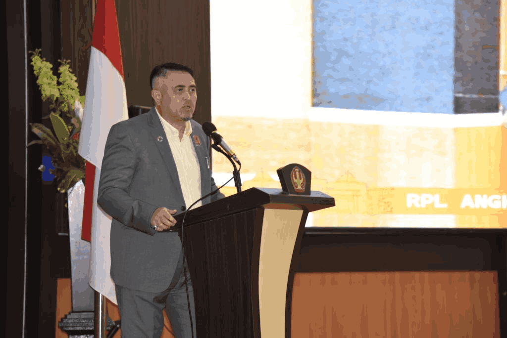
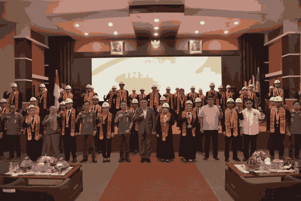
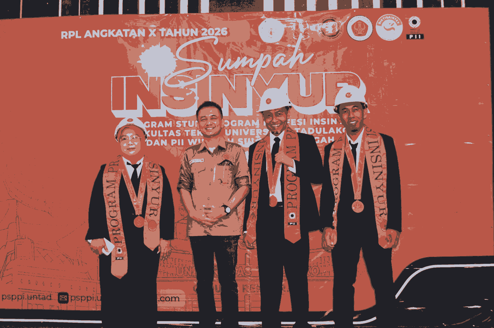
Untad Kukuhkan 49 Insinyur Baru, Perkuat Profesionalisme dan Integritas Profesi
Post author:Arba Arief
Post published:Februari 12, 2026
Bertempat di Aula Fakultas Kedokteran Untad,
sebanyak 49 peserta mengikuti Prosesi Pengambilan Sumpah Insinyur Program Studi Program Profesi Insinyur Fakultas Teknik Universitas Tadulako dan PII Wilayah Sulawesi Tengah yang diselenggarakan pada Rabu pagi (11/02/2026).
Dalam sambutannya, Dekan Fakultas Teknik Ir. Andi Arham Adam, ST.,M.Sc.,Ph.D menegaskan bahwa profesi insinyur memiliki peran strategis dalam menjawab tantangan pembangunan di Sulawesi Tengah.
“Di Sulawesi Tengah ini, kebutuhan akan rekayasa yang andal dan bertanggung jawab sangat nyata. Pembangunan infrastruktur dasar, perumahan dan pemukiman, layanan air bersih, pembangunan energi, hingga industrialisasi yang berwawasan lingkungan sangat nyata dan kita butuhkan.”
Ia menekankan bahwa gelar insinyur bukan sekadar simbol akademik, melainkan amanah yang harus dijalankan dengan integritas dan orientasi pelayanan kepada masyarakat. Selain itu, Dekan Fakultas Teknik juga menyampaikan pesan moral kepada para insinyur yang akan dilantik agar senantiasa menjunjung tinggi etika profesi dan keselamatan kerja dalam setiap keputusan teknis yang diambil.
“Keputusan teknis saudara akan berdampak pada keselamatan manusia, keselamatan lingkungan dan keberlanjutan dan tentunya ini adalah merupakan kewajiban kita bersama. Tidak ada keberhasilan proyek yang layak bila mengabaikan sisi-sisi K-3, kualitas dan perlindungan penduduk.”
Menutup sambutannya, Ia berharap sumpah yang diikrarkan tidak hanya menjadi formalitas, melainkan komitmen moral sepanjang karir profesional para insinyur.
“Semoga sumpah yang saudara ikratkan menjadi kompas moral dalam setiap keputusan.”
Dalam sambutannya, Rektor Universitas Tadulako Prof. Dr. Ir. Amar ST.,MT.,IPU.,ASEAN Eng menekankan pentingnya peningkatan jumlah dan kualitas insinyur di Indonesia. Ia mengungkapkan bahwa rasio insinyur Indonesia masih tertinggal dibandingkan negara lain.
“Masih punya rasio insinyur yang sangat kurang di Indonesia dibanding beberapa negara lain. Seperti Vietnam dan Korea Selatan, itu per 1 juta penduduknya sekitar 9.000 insinyur. Sementara kita di Indonesia kurang lebih 2.600 sampai 3.000-an insinyur, masih jauh sekali.”
Ia mengingatkan bahwa di era perkembangan teknologi dan kecerdasan buatan saat ini, insinyur dituntut untuk terus meningkatkan kompetensi.
“Di era sekarang ini jangan main-main. Kalau hanya pengetahuan, kita sudah kalah dengan artificial intelligence. Sekarang begitu banyak aplikasi yang sangat mempermudah.”
Menutup sambutannya, Rektor mengajak seluruh Insinyur yang dilantik untuk bekerja secara profesional dan menjadikan sumpah sebagai pedoman dalam menjalankan tugas.
“Mari kita bekerja secara profesional sesuai dengan harapan-harapan yang dilakukan. Dalam sumpah insinyur itu sangat jelas bagaimana menjalankan profesi dengan jujur, adil, bertanggung jawab, mematuhi kode etik dan standar profesional.” Tutupnya. AA & Mutia
The Relationship Between Land Characteristics and Quality with Land and Crop Management

JOURNAL OF AGRICULTURAL TECHNOLOGYAND NATURAL FARMING
Irma Abdul Rahman1, Djaria Dalanggo1, Inang Jafar1, Nurdin2, Nurmi3
1Mahasiswa, Universitas Negeri Gorontalo
2Dosen Pengampuh Mata Kuliah, Universitas Negeri Gorontalo
3Dosen Pengampuh Mata Kuliah, Universitas Negeri Gorontalo
E-mail Korespondensi: irmaabdulrahman09@gmail.com
ABSTRACT
Land characteristics and quality are fundamental factors determining the success of land and crop management in agricultural systems. Understanding the relationship between them is key to designing appropriate, efficient, and sustainable management strategies. This review article is compiled to comprehensively examine the relationship between land characteristics and quality with land and crop management based on synthesis from various previous studies. A systematic literature search was conducted on selected scientific journals relevant to the review topic. This review reveals that land characteristicsincluding physical, chemical, and biological soil properties directly influence land quality which in turn determines land suitability for various crop types and crop responses to management inputs. Land management such as tillage, fertilization, irrigation, and conservation must be tailored to site-specific land characteristics and quality to optimize productivity while maintaining land resource sustainability. Land quality assessment through land evaluation approaches becomes an important instrument in determining land use directions and appropriate management recommendations. This review is expected to serve as a useful academic reference for students, researchers, and practitioners in understanding the reciprocal relationship between land characteristics, land quality, and management practices to achieve sustainable agriculture.
Keywords:land characteristics, land quality, land management, crop management, land evaluation.
A Review of Urban Sprawl Concept: Characteristics, Causes, and Impacts on Agricultural Land
JOURNAL OF AGRICULTURAL TECHNOLOGYAND NATURAL FARMING
Rahmiyati Modjo1, Rahmawaty Amir Isa1, Yulian Lamato1, Nurdin2, Nurmi3
1Mahasiswa, Universitas Negeri Gorontalo
2Dosen Pengampuh Mata Kuliah, Universitas Negeri Gorontalo
3Dosen Pengampuh Mata Kuliah, Universitas Negeri Gorontalo
E-mail Korespondensi: rahmimodjo03@gmail.com
ABSTRACT
Urban sprawl or uncontrolled urban development into peri-urban areas has become a global phenomenon threatening the sustainability of productive agricultural land. This review article is compiled to provide a comprehensive overview of the concept of urban sprawl, its development characteristics, causal factors, and impacts on agricultural land based on literature reviews from various previous studies. A systematic literature searchwas conducted on selected scientific journals relevant to the review topic. The review reveals that urban sprawl is characterized by unplanned development patterns with ribbon development types (elongated following transportation corridors) and leapfrog development (discontinuous jumps), low density, and fragmentation of agricultural landscapes. Factors causing urban sprawl include population growth and urbanization, economic factors and land values, weak spatial planning policies, household behavior, and accessibility and infrastructure. The impacts of urban sprawl on agricultural land are significant, including conversion of productive agricultural land, land fragmentation, decreased food production, threats to food security, disruption of irrigation systems, and socio-economic impacts on farmers. This review is expected to serve as a useful academic reference for students, researchers, and practitioners in understanding urban sprawl phenomena and formulating control policies to protect agricultural land.
Keywords:urban sprawl, agricultural land, land conversion, peri-urban areas, spatial planning
Kajian Kelayakan Pengembangan Usahatani Konservasi Terintegrasi Berbasis Teras Sering di Kabupaten boalemo.
RINGKASAN EKSEKUTIF
Nurdin, Fauzan Zakaria, Agustinus Moonti, Rival Rahman.
Pekerjaan Swakelola Kerjasama Bapppeda Kabupaten Boalemo dengan Universitas Negeri Gorontalo, Tahun 2025.
Kajian ini bertujuan menganalisis karakteristik dan kualitas lahan sebagai dasar usahatani konservasi terintegrasi berbasis terasering, potensi erosi tanah akibat usahatani konvensional, kemampuan dan kesesuaian lahan komoditas usahatani konservasi terintegrasi, kelayakan penerapan teknik konservasi tanah dan air berbasis terasering, kelayakan ekonomi usahatani konservasi terintegrasi, kebutuhan fisik minimum dan kehidupan yang layak, serta menganalisis skenario implementasi usahatani konservasi terintegrasi berbasis terasering. Metode kajian yang digunakan untuk analisis karakteristik dan kualitas lahan adalah metode survei dan observasi lahan, sementara analisis potensi erosi tanah menggunakan metode USLE, dan erosi yang dapat ditoleransi, analisis kemampuan lahan menggunakan metode USDA dan kesesuaian lahan komoditas usahatani konservasi terintegrasi menggunakan kerangka kerja evauasi lahan menurut FAO (1976), analisis kelayakan penerapan teknik konservasi tanah berbasis terasering berdasarkan tingkat kekritisan lahan, erosi dan kemampuan lahan, analisis kelayakan usahatani konservasi terintegrasi menggunakan keunggulan komparatif, kompetitif, dan analisis finansial, analisis kebutuhan fisik minimum dan kehidupan yang layak menggunakan metode komparasi, serta analisis skenario implementasi usahatani konservasi terintegrasi berbasis terasering menggunakan metode paduserasi.
Hasil yang diperoleh menunjukkan bahwa kelas kemampuan lahan di Kabupaten Boalemo didominasi kelas III sampai Kelas VI dengan faktor pembatas dominan berupa lereng dan erosi tanah. Sementara kelas kesesuaian lahan aktual untuk semua komoditas pertanian yang dinilai didominasi kelas tidak sesuai (N) dengan faktor pembatas bahaya erosi yang dapat diperbaiki dengan pembuatan terasering, sehingga kelas kesesuaian potensial menjadi sesuai marjinal (S3) dan cukup sesuai (S1). Tingkat bahaya erosi lebih besar dari erosi yang dapat ditoleransi, sehingga tingkat kekritisan lahan di Kabupaten Boalemo didominasi kelas agak kritis. Disain teknik konservasi tanah dan air yang layak di wilayah Kabupaten Boalemo adalah teras datar, teras gulud, teras kredit dan teras bangku. Kebutuhan hidup layak di Kabupaten Boalemo sebanyak Rp. 41.818.857,14/tahun atau Rp. 3.484.905/bulan. Skenario implementasi sistem usahatani konservasi secara monokultur: Skenario I = Durian + Teras dan Pala + Teras; Skenario II = Kakao + Teras, Bambu + Teras, dan Mete + Teras; Skenario III = Sawit + Teras (dengan perbaikan input produksi). Sementara secara polikultur, yaitu: Skenario I = Pala - Kakao - Durian + Teras; Skenario II = Jagung - Kakao - Durian + Teras, Bambu Petung - Pala - Jagung + Teras; dan Skenario III = Bambu Petung - Mete - Sawit + Teras; Kelapa - Jagung - Kakao + Teras.
Saran yang diberikan yaitu: pada lahan dengan lereng 0 - 15% tetap diterapkan teknik konservasi tanah dan air mengingat laju erosi tanah dan tingkat kekritisan lahan menunjukkan tren terus meningkat, diantaranya dengan teknik: SPA: saluran pembuangan air, Sra: sumur resapan, Bi: biopori, Rr: rorak. Pada lahan dengan lereng >15% diterapkan teknik konservasi tanah dan air dengan terasering, tetapi harus dipaduserasikan dengan karakteristik dan kualitas lahan, seperti kedalaman solum tanah, vegetasi eksisting dan kondisi usahatani petani itu sendiri.
Rekomendasi Kebijakan yang diajukan adalah pemilihan komoditas usahatani dengan pola tanam monokultur, baik non subsidi maupun subsidi (pembangunan teras, bibit) direkomendasikan yang memiliki nilai net profit sebanyak lebih dari Rp. 3.484.905/bulan atau mampu memenuhi kebutuhan hidup layak di Kabupaten Boalemo. Pemilihan komoditas usahatani dengan pola tanam polikultur, baik non subsidi maupun subsidi (pembangunan teras, bibit) direkomendasikan juga yang memiliki nilai net profit sebanyak lebih dari Rp. 3.484.905/bulan atau mampu memenuhi kebutuhan hidup layak di Kabupaten Boalemo. Program usahatani konservasi terintegrasi ini merupakan terobosan yang inovatif oleh Pemerintah Kabupaten Boalemo, sehingga membutuhkan penanganan serius dan dukungan semua pihak yang terkait, melalui: (1) Sosialisasi secara intens kepada semua pihak yang akan terlibat di dalamnya dari aspek hulu sampai hilir., (2) Pendampingan dan pemberdayaan secara berkelanjutan terhadap semua pihak yang terlibat., (3) Percepatan realisasi program dan kegiatan, terutama subsidi terasering dan bibit tanaman kepada petani dan pekebun., (4) Monitoring dan evaluasi secara berkala terhadap kemajuan dan capaian program ini setiap tahunnya., (5) Pelibatan para pihak dan mitra dalam program ini secara kolaboratif, baik dengan pihak kementrian, perguruan tinggi, Ngo dan masyarakat lainnya yang strategis. Perlu didorong pemberian reward bagi petani, kelompok tani, masyarakat dan NGo yang berhasil melaksanakan program dan kegiatan ini, diantaranya: pemberian bantuan sapi untuk mengoptimalkan potensi pakan dari usahatani konservasi, keringanan retribusi usaha, atau bentuk lainnya. Sementara petani yang tetap bertani di lahan berlereng tanpa menerapkan terasering dan menimbulkan bencana longsor setempat perlu diberi punishment, baik ganti rugi lingkungan maupun sanksi pidana sebagaimana UU No. No. 37 Tahun 2014 tentang Konservasi Tanah dan Air.
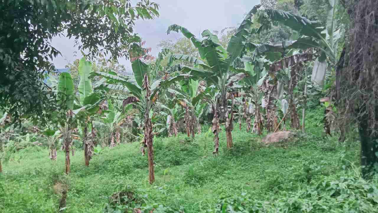
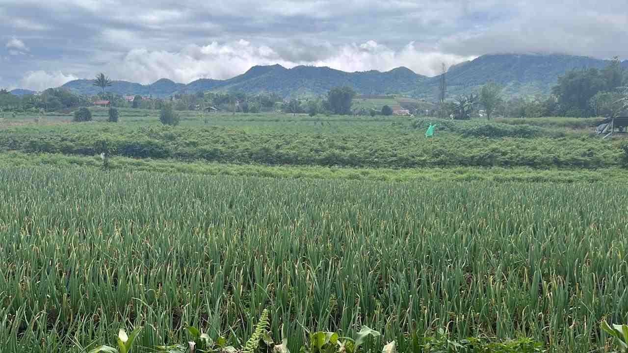
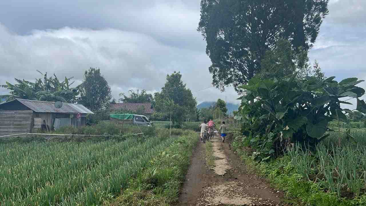
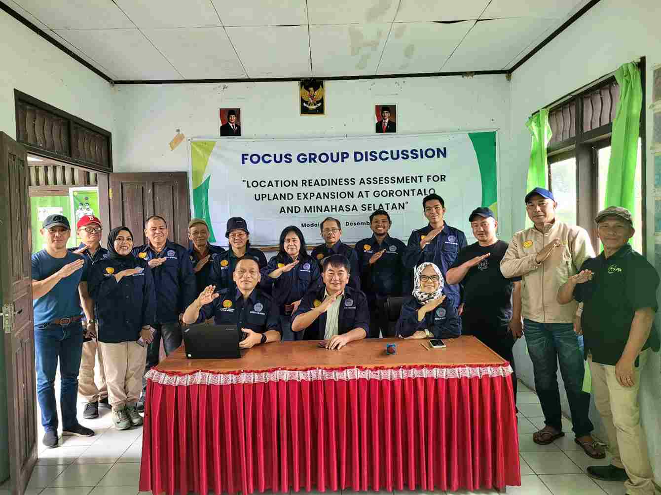
Location Readiness Assessment for Upland Expansion At Gorontalo Districts and South Minahasa Districts (The Development of Integreted Farming System in Upland Areas - Upland Project)
![]()
RINGKASAN
Dr. Ir. Jooudie N. Luntungan as (Team Leader) Mapping/GIS; Dr. Ir. Edy Lengkong as Agronomy Expert; Dr. Ir. Ellen C. Pakasi as Value Chain Expert; Dr. Ir. Nordy Waney, Ms as Rural Socio-economics Expert; Dr.Ir.Tiny Mananoma,MT.,IPM.,ASEAN Eng as Irrigation Expert; Prof. Dr. Zetly Tamod, SP. M.Si as Environment Expert; Dr. Ir. Adeleyda Lumingkewas, SP. M. Si as Ass. Agronomy Expert; Dr. Ir. Sofia Wantasen, M.Si as Ass Environment Expert; Prof. Dr. Nurdin, S.P, M.Si ( Ass.Mapping/Soil Science (Counterpart Universitas Negeri Gorontalo); Ir. Yani Kamagi, MP (Surveyor); Dr. Ir. Tommy Lolowong, MS (Surveyor); Surono, SP., M.Sc. (Surveyor); Frederick Djojosaputro, SP (Surveyor); Syafrizal Umaternate, ST (Surveyor); Roby Waworuntu, (Surveyor)
Kabupaten Gorontalo dan Kabupaten Minahasa Selatan, Tahun 2024
Pengembangan Pisang Gapi di Kabupaten Gorontalo sebagai berikut: Investasi Infrastruktur: Alokasi anggaran untuk pembangunan jalan akses (Rp 525 juta), terasering lahan (Rp 120 juta), pompa & pipa (Rp 120 juta), serta reservoir air pertanian (Rp 200 juta) menunjukkan fokus pada peningkatan aksesibilitas dan penyediaan sumber air yang vital untuk mendukung aktivitas pertanian. Produksi dan Pengelolaan Pertanian: Pengadaan bahan ajir (Rp 140 juta), bibit pisang (Rp 812,5 juta), pupuk organik cair (Rp 41,25 juta), serta pupuk padat/kandang (Rp 437,5 juta) menunjukkan fokus pada peningkatan hasil panen dengan metode organik. Alokasi alat-alat pertanian seperti cultivator, banana cutter, handsprayer, dan gergaji mesin (total Rp 247 juta) mendukung mekanisasi untuk efisiensi operasional. Dukungan Logistik dan Penyimpanan: Pembangunan warehouse (Rp 500 juta) dan kube warehouse (Rp 41,2 juta) menunjukkan langkah untuk memperbaiki sistem penyimpanan hasil panen, sehingga dapat mengurangi kerusakan atau kehilangan hasil. Dukungan Keuangan Mikro: Alokasi dana sebesar Rp 296,25 juta untuk akses ke pembiayaan mikro menandakan upaya pemberdayaan petani dalam mengelola modal dan investasi usaha tani. Skala dan Total Anggaran: Dengan total anggaran sebesar Rp 4,861 miliar, program ini menunjukkan skala yang besar dan menyeluruh, mencakup peningkatan infrastruktur, produktivitas, dan keberlanjutan pertanian. Optimalisasi Infrastruktur: Pastikan kualitas pembangunan jalan akses, reservoir air, dan terasering sesuai dengan spesifikasi teknis agar infrastruktur dapat bertahan lama dan mendukung aktivitas pertanian secara maksimal. Tambahkan evaluasi kebutuhan reservoir tambahan jika cakupan irigasi untuk lahan luas masih kurang. Efisiensi Alat dan Material Pertanian: Pastikan distribusi alat pertanian seperti banana cutter, handsprayer, dan cultivator sesuai dengan kebutuhan di lapangan untuk menghindari underutilization. Tinjau kembali kebutuhan bahan ajir untuk memastikan jumlah sesuai dengan total area tanam dan jenis tanaman.Optimalisasi. Penggunaan Pupuk Organik: Lakukan pelatihan bagi petani tentang cara aplikasi pupuk organik yang tepat untuk meningkatkan hasil panen sekaligus menjaga kesuburan tanah. Perkuat monitoring terhadap penggunaan pupuk untuk memastikan efisiensi biaya. Dukungan Keuangan Mikro: Tingkatkan sosialisasi program akses keuangan mikro untuk mendorong lebih banyak petani memanfaatkannya. Berikan pelatihan manajemen keuangan kepada petani untuk memastikan dana yang diperoleh dimanfaatkan secara produktif. Peningkatan Penyimpanan dan Distribusi: Pastikan warehouse dan fasilitas penyimpanan lainnya dilengkapi dengan teknologi penyimpanan yang memadai untuk menjaga kualitas hasil panen. Rencanakan sistem distribusi yang lebih baik, termasuk penyediaan armada logistik tambahan jika diperlukan. Keberlanjutan dan Pengawasan: Tetapkan indikator kinerja utama (KPI) untuk mengevaluasi keberhasilan program secara berkala. Libatkan petani lokal dalam perencanaan dan pelaksanaan program untuk meningkatkan rasa memiliki dan keberlanjutan proyek.
Pengembangan kentang di Kabupaten Minahasa Selatan sebagai berikut: Investasi Infrastruktur Lahan dan Air: Alokasi anggaran sebesar Rp 300 juta untuk pembangunan 2 unit pompa dan pipa (deep wells) menunjukkan fokus pada penyediaan air untuk area seluas 20 ha, bukan pada “deep wells”nya. Pembangunan jalan akses pertanian sepanjang 2 km dianggarkan Rp 700 juta, memberikan dukungan transportasi logistik hasil panen. Produksi dan Pengelolaan Pertanian: Pengeluaran terbesar dialokasikan untuk input produksi, seperti benih, pupuk, dan pestisida awal (Rp 4,8 miliar untuk 120 ha). Pengadaan benih unggul (G0 dan G2) dengan alokasi total Rp 470 juta menunjukkan langkah untuk mendukung produktivitas jangka panjang. Pengadaan alat pertanian seperti cultivator (Rp 30 juta) dan penyemprot (Rp 1,6 miliar) menunjukkan komitmen terhadap mekanisasi, meskipun volume alat yang dibeli mungkin perlu diperiksa apakah mencukupi kebutuhan. Skala dan Target Volume 2025: Target pengelolaan 120 ha menunjukkan skala yang cukup besar untuk mendukung ketahanan pangan local dan regional. Penyediaan 4 unit alat untuk mendukung proses pertanian menandakan pendekatan bertahap dalam meningkatkan efisiensi operasional. Optimalisasi Infrastruktur Air: Evaluasi kembali kebutuhan unit pompa dan pipa untuk memastikan cakupan air yang memadai. Jika memungkinkan, tambahkan unit untuk mendukung lebih banyak area lahan. Efisiensi Pengelolaan Input Pertanian: Pastikan alokasi benih, pupuk, dan pestisida sesuai dengan kondisi tanah dan cuaca lokal untuk menghindari pemborosan.Lakukan pelatihan bagi petani untuk meningkatkan efisiensi penggunaan input pertanian. Peningkatan Mekanisasi: Dengan hanya 2 cultivator dan 2 hand sprayers, evaluasi apakah jumlah alat ini cukup untuk mengelola 120 ha secara optimal. Tambahkan unit jika perlu untuk mengurangi waktu kerja dan meningkatkan produktivitas. Pembangunan Jalan Akses: Pantau pembangunan jalan akses untuk memastikan efisiensi logistik distribusi hasil panen. Jika jalan sudah dibangun, tambahkan dukungan logistik seperti kendaraan pengangkut. Pengelolaan Anggaran: Pastikan bahwa seluruh anggaran yang dialokasikan benar-benar digunakan secara efektif untuk kegiatan yang direncanakan. Lakukan audit rutin untuk memastikan transparansi dan akuntabilitas anggaran. Monitoring dan Evaluasi: Tetapkan indikator kinerja utama (KPI) untuk mengukur keberhasilan setiap kegiatan, seperti peningkatan hasil panen per hektar dan efisiensi penggunaan alat. Keberlanjutan Program: Rencanakan strategi untuk mengintegrasikan petani lokal dalam pengelolaan program agar proyek ini memiliki dampak jangka panjang. Infrastruktur: Sistem irigasi yang dapat diterapkan di Lokasi Target yaitu desa Kakenturan disesuaikan dengan ketersediaan sumber air yaitu air permukaan dan juga mata air lokal. Dengan demikian memungkinkan untuk menerapkan sistem Pumping and pipe (Deep wells).
Kategori
- Abstract 2006
- Abstract 2009
- Abstract 2011
- Abstract 2012
- Abstract 2013
- Abstract 2014
- Abstract 2016
- Abstract 2018
- Abstract 2019
- Abstract 2020
- Abstract 2021
- Abstract 2022
- Abstract 2023
- Abstract 2024
- Abstract 2025
- Abstract 2026
- Buku
- Kunjungan Luar Negeri
- Mata Kuliah
- Pengukuhan Guru Besar, Prof. Dr. Nurdin, SP, MSi
- Profesi Ir
- Project 2009
- Project 2010
- Project 2013
- Project 2018
- Project 2019
- Project 2020
- Project 2021
- Project 2022
- Project 2023
- Project 2024
- Project 2025
- Publikasi Ilmiahku
- Soil Scientist from Gorontalo
- Tugas Pembantuan sebagai Kepala Dinas Pertanian Kabupaten Boalemo
Arsip
Blogroll
- a-SintaID
- b-Google Scholar
- c-Scopus ID
- d-Web of Science (WoS) ID
- e-ResearchGate
- f-Academia.edu
- g-SciProfiles
- h-Loop ID
- i-LinkedIn
- j-OrcidID
- k-figshare
- l-Youtube
- m-Twitter
- n-Facebook
- o-Universitas Negeri Gorontalo
- p-BIMA-Kemendikbud RI
- q-FAPERTA UNG
- r-LP2M UNG
- s- LP3M UNG
- t-SIMPPM UNG
- u-SIMLIT UNG
- v-Rispro LPDP
- w-BRIIN
- x-PDDIKTI
- y-GRS BPDPKS
- z-kampusmerdeka
- z1-ANJANI
- z10-MyASN
- z10-SIAT UNG
- z11-Aplikasi SIAGA
- z12-SPADA Indonesia
- z13-SISTER
- z14-tesaurus.kemdikbud
- z15-UKBI
- z16-typoonline
- z17-Turnitin
- z18-Zetero
- z2-eHAKI
- z20-Himpunan Ilmu Tanah Indonesia(HITI)
- z21-BKN
- z21-Kementan RI
- z22-BPS Provinsi Gorontalo
- z23-BPS Kabupaten Boalemo
- z24-BPS Kabupaten Bone Bolango
- z25-BPS Kabupaten Gorontalo
- z26-BPS Kabupaten Gorontalo Utara
- z27-BPS Kabupaten Pohuwato
- z3-Arjuna
- z4-DIKTI
- z5-GARUDA Dikti
- z6-SIM Karier dan SDM Kemendikbud
- z7-KBBI
- z8-Kedaireka
- z9-RAMA